 |
Weather Eye with John Maunder |
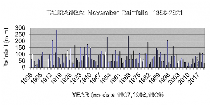
The graph below shows the range of Tauranga's November rainfalls, from an extreme high of 357 mm in 1916 to a low of only 7 mm in 1984.

The second wettest October was 1928, when 269 mm was recorded; and the second driest October was in 1928, when only 11 mm fell.
The long-term average rainfall for Tauranga in the month of November is 84 mm.
The rainfall in November 2021 was 34 mm.
The graph of the November rainfall shows generally normal variations from year to year but with a decrease from 130 mm in the 50 year average from 1911-60, to 88 mm in the 50 year average from 1961-2010.
Since 1898, there have been 11 October months with a rainfall of 200 mm or more (10 of which occurred during the period 1900-1958), and only one October month since then has recorded this much. Eleven October months have also experienced rainfalls of 25 mm or less.
In chronological order the eleven wettest October months are 1900, 1905, 1916, 1918, 1921, 1926, 1928, 1941, 1952, 1958, and 1983. In contrast the eleventh driest October months are 1906, 1938, 1963, 1965, 1969, 1973, 1984, 1993, 2010, 2013, 2015 and 2020.
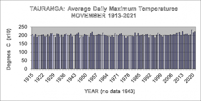
Tauranga November Average Afternoon Temperatures 1913-2021
Temperatures have been recorded in the Tauranga area at several sites in the last 100 years, including the current Tauranga Airport site from June 1990.
The graph shows details of the average daily maximum temperatures (called simply ‘afternoon') for Tauranga for November from 1913-2021.

The average afternoon temperature for November 2021 for Tauranga was 22.2 degrees C.
It's very common for areas such as Tauranga to have had different observation sites during the years, and readings from the earlier sites have been adjusted to the present site using standard climatological procedures. The temperature series described here is a record of what the temperature would have been if the current observation site, Tauranga Airport, had been used throughout the period.
It's important to note, particularly in considering climate change, the methodology used in computing any 'official” set of climate observations is very important as otherwise erroneous conclusions may be drawn.
Traditionally, temperature observations have been recorded with a set of maximum and minimum temperature thermometers.
These record the daily maximum temperature, usually recorded in mid-afternoon, and daily minimum temperature, usually recorded just before dawn.
The long-term average afternoon temperature in November for Tauranga is 20.1 degrees Celsius, ranging from the cool November months of 1976 (18.4 degrees Celsius), and 1946 (18.5 degrees Celsius), to the warm November months of 2019 (23.2 degrees Celsius), 2013 (22.3 degrees C) , and 2021 (22.2 degrees Celsius).
The graph of the average afternoon temperatures for November shows generally normal variations from November to November during the last 100 years. The average November afternoon temperatures during the 50 years from 1962-2013 of 20.1 degrees Celsius was similar to the 20.1degrees Celsius recorded in the 50 years from 1914-1961. However the last three Novembers have shown an average of 22.3 degrees C.
From 1913 to 2021, there have been nine November months with an average afternoon temperature of 21.5 degrees Celsius or more; and seven November months have had an average afternoon temperature of19.0 degrees Celsius or less.
The five warmest November months (in terms of afternoon temperatures), on record, in chronological order, are 1954, 2011, 2013, 2019, and 2021.
By contrast, the fifth coolest November months (in terms of afternoon temperatures), on record, in chronological order, are 1930, 1946, 1976, 1991, and 1985.
************
For further Infomation about a wide range of weather/climate matters see my new book Fifteen shades of climate... the fall of the weather dice and the butterfly effect.
The book is available through the web site amazon.com. Just Google 'fifteen shades of climate” for details.

