 |
Weather Eye with John Maunder |
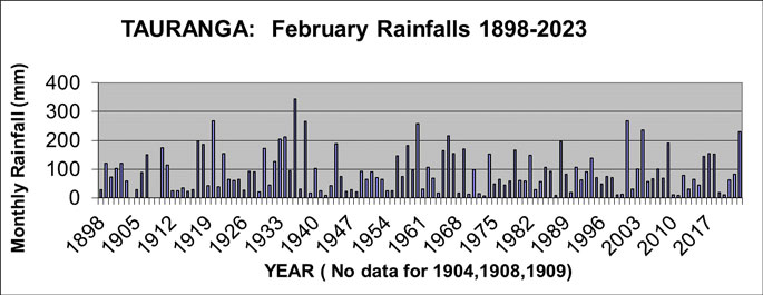
Rainfalls for the month of February have been recorded in Tauranga since 1898 (except for 1904, 1908, and 1909).
The graph of February rainfalls in Tauranga shows the range of rainfalls from a high of 343 mm in 1936 to a low of only 7 mm in 1973.
The graph shows predominantly "normal" variations from year to year.
Ten February months have had a rainfall of less than 15 mm. Ten February months also have had a rainfall of 200 mm or more.
The wettest February was 1936 with 343 mm, and the second wettest February was 2001 when 268 mm was recorded.
The driest February month was 1973 with 7 mm, and the February months of 1942, 1987, and 2011 each had a rainfall of 8 mm.
The rainfall for February 2023 was 231 mm. The long-term February rainfall for Tauranga is 90 mm.
In chronological order, the wettest nine February months were 1920, 1933, 1934, 1936, 1938, 1960, 1966, 2001, 2004 and 2023.
In chronological order, the driest nine February months were 1942, 1970, 1972, 1973, 1987, 1999, 2000, 2010, 2011 and 2020.

******************************************************************************
Afternoon Temperatures 1913-2023
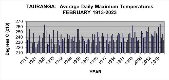
Temperatures have been recorded in the Tauranga area at several sites during the last 120 years, including the current Tauranga Airport site from June 1990.
The average afternoon temperature for February 2023 was 23.4 degrees, 2.6 degrees cooler than the 26.5 degrees Celsius recorded in February 2020, which was the warmest February since records began in 1913.
It is very common for areas such as Tauranga to have had different observation sites during the years; and the readings from the earlier sites have been adjusted to the present site using ‘standard climatological procedures'. It's considered the temperature series described here is a fair and true record of what the temperature would have been if the current observation site (Tauranga Airport) had been used throughout the period. It's important to note that in considering ‘climate change', the methodology used in computing an 'official' set of climate observations is very important – as otherwise erroneous conclusions may be drawn.
Traditionally, temperature observations have been recorded with a set of maximum and minimum temperature thermometers. These record the daily maximum temperature (usually recorded in mid-afternoon), and daily minimum temperature (usually recorded just before dawn).
This analysis of February temperatures for Tauranga is for the average daily maximum temperatures.


