 |
Weather Eye with |
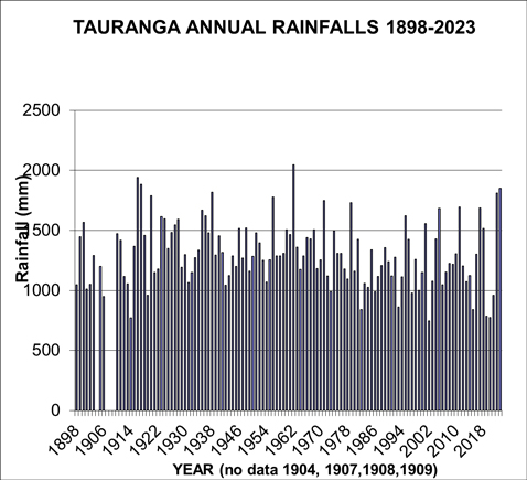
Monthly rainfalls for Tauranga have been recorded at several recording sites during the last 125 years.
The rainfall for Tauranga for 2023 of 1852 mm, the fourth highest on record (since 1898) .
From January 1898 to December 1904, the observation site was described as the Tauranga Harbour, from November 1904 to April 1907 the site was described as simply ‘Tauranga'. From January 1910 to December 1923 the site was Waikareao, in Otumoetai; from January 1924 to September 1940 the site was at 148 Waihi Rd, in Judea; from October 1940 to January 1941 the site was at Te Puna; and from February 1941 to now, the site is Tauranga Airport.
The methodology used in adjusting the older sites to the current observing site was published in the NZ Meteorological Service Miscellaneous Publication No 180 in 1984. It is considered that the homogeneous rainfall series described here is a fair and true record of what the rainfall would have been if the current observation site (Tauranga Airport) had been used since 1898.
This should be coupled with the understanding that although standard accepted methodologies have been used, any adjustments are only estimates of what would have occurred if the location of the rainfall records had always been in the same place with the same surroundings and the same or similar recording gauge.
In terms of climate change (such as is it getting wetter or drier, or warmer or colder), the methodology used in computing an ‘official' set of climate observations is very important, as otherwise erroneous conclusions may be drawn.
The long-term average rainfall for Tauranga for the calendar year is 1300 mm, ranging from a low of 747 mm in 2002, to a high of 2049 mm in 1962. For comparison, the rainfall for the year 2020 was 774 mm which was the third driest year on record, and for 2021 it was 959 mm, while 2022 had 1812 mm the fifth highest on record. and 2023, the rainfall was 1852 mm, the fourth highest on record.
Since 1898, there have been only six years with a rainfall of less than 900 mm, they are 1914, 1982, 1993, 2002, 2019, and 2020, and there has only been five years with a rainfall of more than 1800 mm; they are the two consecutive years of 1916 and 1917, plus 1938 and 1962.
In chronological order, the wettest years occurred in 1916, 1917, 1920, 1935, 1938, 1956, 1962, 1979, 2005, 2011, 2022 and 2023; and the driest years occurred in 1906, 1914, 1919, 1973, 1982, 1986, 1993, 1997, 1999, and 2002.
The average rainfall in Tauranga for the 50 years 1911-60 was 1365 mm, compared with the average rainfall for the 50 years 1961-2010 of 1263 mm.

*******
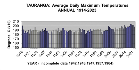
Tauranga Average Annual Afternoon Temperatures 1914-2023
The average afternoon temperature in 2022 was 20.2 degrees Celsius, which made 2022 the third equal warmest year on record.
Temperatures have been recorded in the Tauranga area at several sites in the last 108 years, including the current Tauranga Airport site from June 1990.
It's very common for areas such as Tauranga to have had different observation sites during the years, and readings from the earlier sites have been adjusted to the present site using standard climatological procedures. The temperature series described here is a record of what the temperature would have been if the current observation site, Tauranga Airport, had been used throughout the period. It's important to note, in considering climate change, the methodology used in computing an official set of climate observations is very important as otherwise erroneous conclusions may be drawn. Traditionally, temperature observations have been recorded with a set of maximum and minimum temperature thermometers.These record the daily maximum temperature, usually recorded in mid-afternoon, and daily minimum temperature, usually recorded just before dawn.
This analysis of temperatures for Tauranga is for the average daily maximum temperatures.
The graph below shows details of the average annual daily maximum temperatures (called simply 'afternoon'), for Tauranga for the years 1914-2023.
The long-term average afternoon temperatures for Tauranga for a calendar year is 18.6 degrees Celsius, including the cool years of 18.1 degrees Celsius in 1976, 18.1 degrees Celsius in 1992, 18.2 degrees Celsius in 1923, and 18.3 degrees Celsius in 1918.
In contrast, Tauranga's warmest years (in terms of the average afternoon temperature) are: 20.4 degrees in 2019, 20.3 degrees in 2020, 20.2 degrees Celsius in 2013, 2021, and 2022, 20.1 degrees Celsius in 1916, 20.0 degrees Celsius in 1998, 19.9 degrees Celsius in 2010, 2016 and 2018, and 19.8 degrees Celsius in 1915, 2011, 2014, and 2017.
Since 1914, there have been nineteen calendar years with an average afternoon temperature of 19.6 degrees Celsius or more. In chronological order these years are: 1914, 1915, 1916, 1928, 1998, 1999, 2005, 2010, 2011, 2013, 2014, 2016, 2017, 2018, 2019, 2020, 2021, 2022. and 2023.
In contrast, there have been 11 calendar years with an average afternoon temperature of 18.5 degrees Celsius or less. In chronological order these years are: 1918, 1920, 1923, 1941, 1945, 1965, 1976, 1977, 1980, 1991, and 1992.

The graph of the average afternoon temperatures for the years 1914-2022 shows generally normal variations from year to year from 1915 to the mid-1990's, followed by several years of above-average temperatures, including nine of the last ten years.
The annual average afternoon temperature shows a warming of about 0.8 degrees Celsius during the 51 years from 1963-2013 from 19.0 degrees Celsius, compared with 18.2 degrees Celsius during the 49 years from 1914-1962.
**************
For further information on a range of weather/climate matters see:
My new book Climate Change : A Realistic Perspective.....Available from Amazon
The title of my climate book "Fifteen Shades of Climate" has been changed to "Climate Change: A Realistic Perspective" to better reflect its contents.


