 |
Weather Eye with |
The following data sets and comments are from the climate4you.com website developed by Professor Ole Humlum who is a Danish Professor Emeritus of Physical Geography at the University of Oslo, and Adjunct Professor of Physical Geography at the University Centre in Svalbard.
The website climate4you.com which he edits endeavours to provide an ongoing climate data website which is updated monthly.
It uses data from significant national and global sites such as NASA, WMO, NOAA, UEA, NCDC, IPCC, BoM, SIDA, UAH, NIWA. The objective of the website is to provide information on meteorological and climatological issues of general and specific interest.
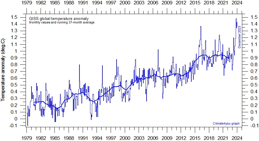
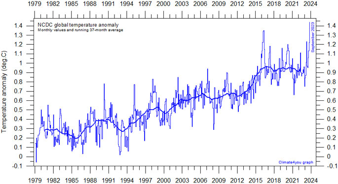
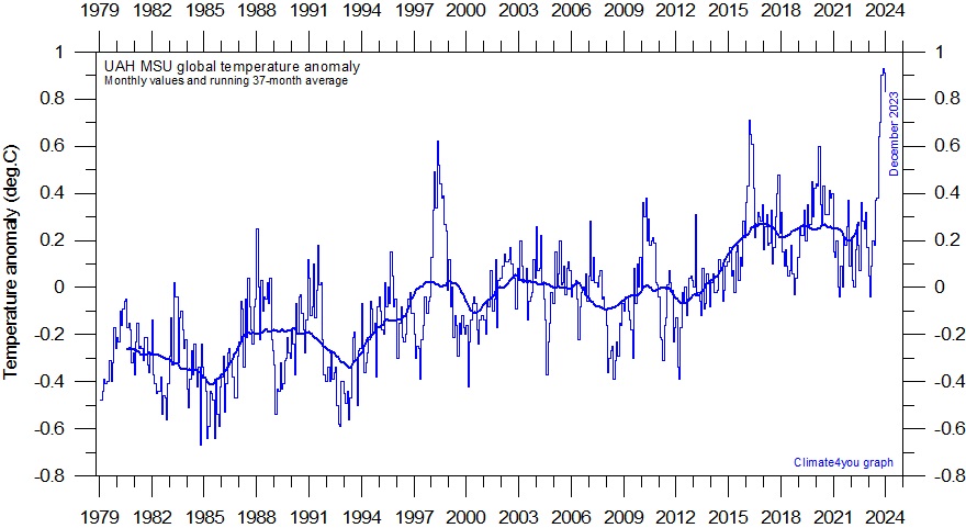
All temperature diagrams shown below have 1979 as the starting year. This roughly marks the beginning of the recent period of global warming, after termination of the previous period of global cooling from about 1940. In addition, the year 1979 also represents the starting date for the satellite-based global temperature estimates (UAH and RSS).
For the three surface air temperature estimates shown (HadCRUT, NCDC and GISS) the reference period differs. HadCRUT refers to the official 'normal” WMO period 1961-1990, while NCDC and GISS as reference instead uses 1901-2000 and 1951-1980, respectively, which results in higher positive temperature anomalies.
For all three surface air temperature records, but especially NCDC and GISS, administrative changes to anomaly values are quite often introduced, even for observations several years back in time.
Some changes may be due to the delayed addition of new station data, while others probably have their origin in a change of technique to calculate average values.
It is clearly impossible to evaluate the validity of such administrative changes for the outside user of these records. In addition, the three surface records represent a blend of sea surface data, moving ships or by other means, plus data from land stations of partly unknown quality and unknown degree of representativeness for their region.
Many of the land stations have also moved geographically during their existence, and their instrumentation changed.
The satellite temperature records also have their problems, but these are generally of a more technical nature and therefore correctable.
In addition, the temperature sampling by satellites is more regular and complete on a global basis than that represented by the surface records.
It therefore is realistic to recognise that the temperature records are not of equal scientific quality. At the same time the big efforts being put into all five temperature databases should be gratefully acknowledged by all interested in climate science.
The following three charts are representative of the several graphs shown in the original website.climate4you.
******************************************************************************
"Climate Change: A Realistic Perspective"
The title of my climate book "Fifteen Shades of Climate" has been changed to "Climate Change: A Realistic Perspective" to better reflect its contents.
Note: I was born in Nelson (New Zealand) and lived inTakaka in 1938-45 when I watched the Takaka River flood, and as a 7 year old I asked two questions ..Why did it rain, and What were the consequences of the rain. I still have questions.
The new book is identical to the old book, with the exception that a new Author's Foreword has been included.
Please Google " Climate Change: A Realistic Perspective"
******************************************************************************


For further information see my new book "Climate Change ... A Realistic Perspective The fall of the weather dice and the butterfly effect". Google "Amazon"

