MetService is issuing a new set of Heavy Rain Warnings and Watches for further rain around Aotearoa as we head into Waitangi Weekend.
This comes as parts of Northland, Auckland and Coromandel set new January rain records after a month of frequent rain which had widespread downpours and flooding.
The warm, humid air which played a part in record-breaking rain around Auckland last Friday is still bringing rain to our shores today.
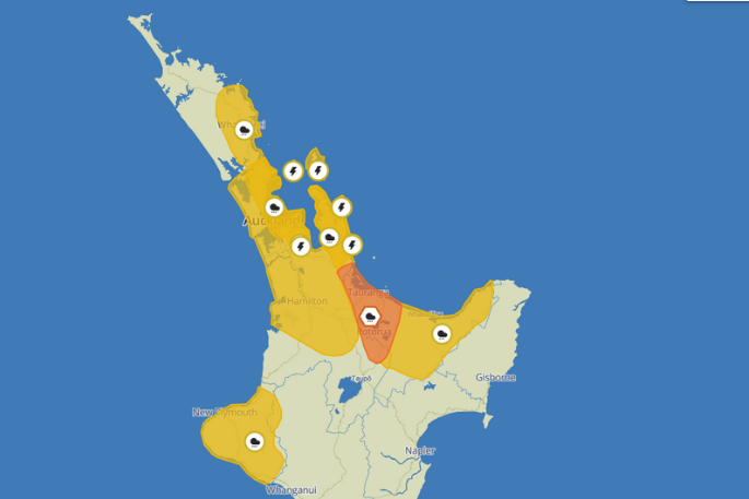
MetService Orange Warnings for Heavy Rain are currently in force around western Bay of Plenty but also Westland south of Otira with Heavy Rain Watches for Northland, Auckland, Coromandel, remaining Bay of Plenty, Taranaki and northern parts of Fiordland.

Bay of Plenty's heavy rain warning has been downgraded to orange. Image: MetService.
'Currently none of these are red warnings but there is still a risk of significant impacts with MetService Orange Warnings, especially when downpours and thunderstorms are involved so keeping up-to-date with the MetService forecast is advised,” says a MetService spokesperson.
MetService meteorologist Lewis Ferris warns, rain falling onto already sodden ground will 'pool faster and impacts/delays should be expected where heavy rain falls.”
'Saturday and Sunday will give a decent chance to dry out for recently impacted areas”
The west coast of South Island had a relatively dry January, but they are kicking off February with a run of rain from today through to Monday with a bit of respite on Saturday.
'This may come as welcome news to those on tank water in the region but with less rain than normal in January we might see a bit of debris end up on roads around Westland,” Ferris states.
The warm, humid air streaming in from the north is not only bringing rain to areas of Aotearoa New Zealand but is continuing to pump up temperatures around the south and east of South Island.
Temperatures in the high 20s or low 30s will be common from Blenheim down to Invercargill from today through Sunday and heat alerts will likely be issued for these hotter than usual temperatures. (Note: Heat Alerts are only issued two days in advance)
'We're forecasting Christchurch to exceed 30°C for three consecutive days, which has happened before but only a handful of times,” informs Ferris.
"In addition, the overnight temperatures are well above average so there is little reprieve from the heat. We advise people to keep hydrated, seek shade, and check in with vulnerable members of your community”
From late on Saturday, New Zealand will have our next widespread band of rain moving over the country from the west, starting in the southwest it spreads over South Island before reaching North Island during the second half of Sunday. It does move through rather quickly, but rain will linger into Monday, especially around the North Island, easing as the day progresses for most people.
'While a front is forecast to deliver rain in the second half of the long weekend it does bring in some cooler air which might be a relief for those struggling to sleep through the heat,” states Ferris.


0 comments
Leave a Comment
You must be logged in to make a comment.