Cyclone Gabrielle poses a very serious threat to NZ - but forecasters keep saying "not 100 per cent locked in yet". So what are forecasters specifically looking at for any possible change in tracking?
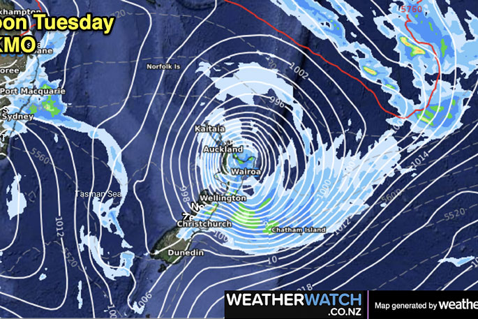
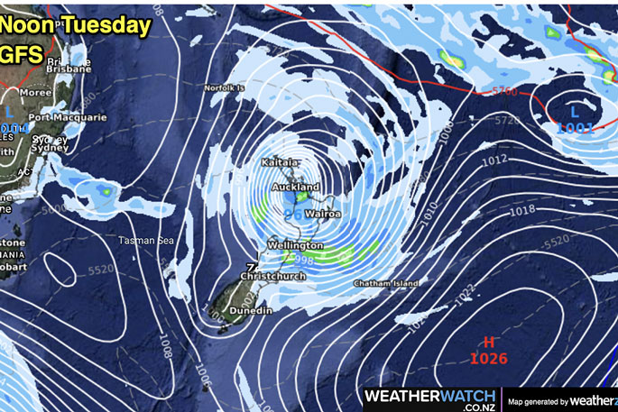
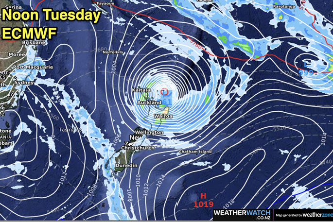
As WeatherWatch said earlier this week, the cyclone has a very clear track towards NZ, but once it reaches us a high pressure zone to the east of NZ will help control movement.
"For those asking if the storm could miss NZ, the best chance for this to happen would be for the high east of the country to either weaken, or to drift further away to the east," says WeatherWatch.co.nz forecaster Philip Duncan.
"It's been a long time since New Zealand weather forecasters have seen such extreme weather modelling for the upper North Island - this is why you're hearing all forecasters talk about this serious set-up.
"But the reason we're saying "path not locked in yet" is due to that high to the east. A slight shift in that high pressure zone can make really dramatic differences to the tracking of the cyclone and therefore the severe weather that goes with it for NZ."
You can have both the most serious storm northern NZ has faced since the 1990s - but still be unclear about precise tracking and who is worst impacted, says Philip.
That has been the case all week and remains that way as we go through Friday.
Modelling is consistent still that the North Island has plenty of severe weather risks.
The further north or east this storm goes the better it will be for NZ.
"Some models have shifted Gabrielle's tracking just a little further east - other models have not budged. This means the north and east of the North Island remain the most exposed to this storm but shows there is certainly still some 'wiggle room' for this powerful cyclone.
"Our weather forecast data updates hourly but global modelling updates a couple times a day. So every 24 hours we all get a big refresh of the world's best modelling and that shifts the tracking each day a little. This is why forecasters can have confidence of a very serious storm - but still not know specific tracking until we get even closer to the event.
"Many New Zealanders will be hoping that this serious storm is allowed to move through faster and offshore - despite our serious concerns forecasters also want this to happen! The high pressure zone to the east is the main controlling feature for that to potentially occur - and if we see any glimmer of a silver lining we'll be sure to let you know."
WHAT THE COMPUTER MODELS SAY AS OF THURSDAY NIGHT:


1 comment
Weather forecasting is NOT an exact science.
Posted on 12-02-2023 13:48 | By morepork
So the forecasters have to qualify their predictions. But the global observation, sensing, and networking we have today, DOES make predictions far more accurate than was the case last century. This was a very good article and explained things very clearly. Even if it isn't 100%, it would be wise to make sure you have things battened down and you are prepared for the worst...
Leave a Comment
You must be logged in to make a comment.