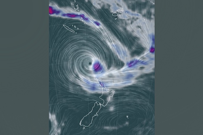
Red Warnings for Heavy Rain are in force for Northland, Auckland, the Coromandel Peninsula and Gisborne north of Tolaga Bay. Red Warnings for Strong Winds are in force for Auckland and the Coromandel Peninsula. Cyclone Gabrielle is located in the north Tasman Sea and is expected to move close to the upper North Island during Monday and Tuesday.
This is expected to be a widespread and significant weather event. Significant heavy rain and potentially damaging winds are forecast for many parts of northern and central New Zealand. In addition, large waves, storm surges and coastal inundation are possible about exposed eastern coasts of the North Island.
On Tuesday it is likely that southeast then southwest gales will be severe in exposed places across the entire North Island and the upper South Island.
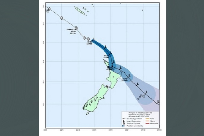
 The latest forecast track map issued by Tropical Cyclone Warning Centre (TCWC) in Wellington.
Rainfall accumulations are also expected to meet warning criteria over Northland, Auckland, Coromandel Peninsula, western Bay of Plenty, Gisborne, Hawke's Bay and Wairarapa, and Moderate Confidence over Waikato, Waitomo, Taumarunui, Taranaki, Taupo and eastern Bay of Plenty.
"We expect to see impacts from this Cyclone from Sunday starting in the north and spreading south to other parts of northern and central New Zealand," says a MetService spokesperson. The amount of rain forecast for the Coromandel Peninsula and northern Gisborne, now including Northland and Auckland, is expected to cause dangerous river conditions and significant flooding. Slips and floodwaters are likely to damage roads, making some roads impassable and possibly isolating communities. Power outages are also very likely. It is important to keep up to date with the latest MetService forecasts in case any changes are made, or further areas are added. Heavy Rain Warning - Red This rain is expected to cause dangerous river conditions and significant flooding. Slips and floodwaters are likely to disrupt travel, making some roads impassable and possibly isolating communities.
Area: Northland Valid: 38 hours from 10:00am Sun 12 Feb to 12:00am Tue 14 Feb Forecast: Expect 200 to 300 mm of rain south of about Kaeo, with 100 to 180 mm of rain elsewhere. Peak intensities of 10 to 15 mm/h, but 20 to 30 mm/h in the south during Monday. Note, a further period of heavy rain likely for western parts of Northland into Tuesday morning. There remains some uncertainty associated with the exact track of Cyclone Gabrielle. Changes may be made in following updates. Area: Auckland, including Great Barrier Island and other islands in the Hauraki Gulf Valid: 42 hours from 10:00am Sun 12 Feb to 4:00am Tue 14 Feb Forecast: Expect 150 to 200 mm of rain, but 200 to 250 mm of rain from the Whangaparaoa Peninsula northwards, with the heaviest rain likely on Monday. Peak intensities of 10 to 15 mm/h, but 25 to 40 mm/h possible Monday afternoon and evening. There remains some uncertainty associated with the exact track of Cyclone Gabrielle. Changes may be made in following updates. Area: Coromandel Peninsula Valid: 47 hours from 10:00am Sun 12 Feb to 9:00am Tue 14 Feb Forecast: Expect 300 to 400 mm of rain about the ranges, and 150 to 250 mm elsewhere, with the heaviest rain likely on Monday. Peak intensities of 10 to 15 mm/h, but 25 to 45 mm/h about the ranges Monday afternoon and evening. There remains some uncertainty associated with the exact track of Cyclone Gabrielle. Changes may be made in following updates. Area: Gisborne north of Tolaga Bay Valid: 39 hours from 3:00pm Sun 12 Feb to 6:00am Tue 14 Feb Forecast: Expect 300 to 450 mm of rain inland and 200 to 250 mm of rain about the coast. The heaviest rain is likely on Monday. Peak intensities of 10 to 15 mm/h, but 25 to 40 mm/h during Monday afternoon and evening. Note, further rain should continue for the rest of Tuesday, and the warning could be extended. Strong Wind Warning - Red These winds are expected to produce widespread damage, especially to trees and powerlines and could lift roofs. Transport and power networks are likely to be significantly impacted, with road closures and power outages. Conditions will be hazardous for motorists and there is a danger to life from flying debris and falling trees or branches. Area: Auckland, including Great Barrier Island and other islands in the Hauraki Gulf Valid: 53 hours from 4:00pm Sun 12 Feb to 9:00pm Tue 14 Feb Forecast: Severe gales, with gusts reaching 120 to 130 km/h, or possibly higher from Monday depending on Cyclone Gabrielle's track. Winds should initially be east to southeast, then are expected to turn south to southwest later on Monday and into Tuesday. Area: Coromandel Peninsula Valid: 42 hours from 3:00pm Sun 12 Feb to 9:00am Tue 14 Feb Forecast: Severe gales, with gusts reaching 120 to 130 km/h, or possibly higher from Monday depending on Cyclone Gabrielle's track. Winds should initially be east to southeast, then are expected to turn south to southwest later on Monday or early Tuesday. Heavy Rain Warning - Orange Heavy rain may cause streams and rivers to rise rapidly. Surface flooding and slips are also possible and driving conditions may be hazardous. Area: Bay of Plenty west of Whakatane Valid: 30 hours from 9:00am Mon 13 Feb to 3:00pm Tue 14 Feb Forecast: Periods of heavy rain. Expect 120 to 180 mm of rain to accumulate. Peak rates of 10 to 15 mm/h, but 20 to 30 mm/h possible during Monday afternoon and evening. Area: Gisborne, from Tolaga Bay southwards Valid: 25 hours from 8:00am Mon 13 Feb to 9:00am Tue 14 Feb Forecast: Expect 100 to 150 mm of rain, but 150 to 250 mm or more about the ranges including the Whareratas. Peak intensities of 20 to 30 mm/h from Monday evening. Note, a further period of heavy rain is likely during Tuesday evening. Area: Hawke's Bay Valid: 24 hours from 10:00am Mon 13 Feb to 10:00am Tue 14 Feb Forecast: Expect 250 to 350 mm of rain in the ranges, and 100 to 150 mm elsewhere. Peak intensities of 10 to 15 mm/h, but 20 to 30 mm/h about the ranges Monday evening and overnight Monday. Note, a further period of heavy rain is possible Tuesday evening and overnight. There remains some uncertainty associated with the exact track of Cyclone Gabrielle. Changes may be made in following updates, and this may be upgraded to a Red Warning, especially for the inland areas. Area: Wairarapa including the Tararua District Valid: 20 hours from 4:00pm Mon 13 Feb to 12:00pm Tue 14 Feb Forecast: Expect 80 to 140 mm of rain to accumulate, especially about the ranges and the eastern hills. Peak rates of 10 to 15 mm/h. Area: Eastern Marlborough south of Blenheim, including Kaikoura Coast Valid: 20 hours from 11:00pm Mon 13 Feb to 7:00pm Tue 14 Feb Forecast: Expect 100 to 160 mm of rain or more to accumulate. Peak rates of 10 to 20 mm/h. Strong Wind Warning - Orange Strong wind gusts could damage trees, powerlines and unsecured structures. Driving may be hazardous, especially for high-sided vehicles and motorcycles. Area: Northland Valid: 59 hours from 10:00am Sun 12 Feb to 9:00pm Tue 14 Feb Forecast: Severe gales, with gusts reaching 120 to 130 km/h, or possibly higher from Monday depending on Cyclone Gabrielle's track. Winds should initially be east to southeast, then are expected to turn south to southwest later on Monday and into Tuesday. Area: Waikato and Waitomo, across to Bay of Plenty and Gisborne, including Taupo and Taihape Valid: 24 hours from 9:00am Mon 13 Feb to 9:00am Tue 14 Feb Forecast: Southeast winds, severe gale gusting 120 km/h to 130 km/h and possibly higher in exposed places. Note the strongest period of winds is expected Monday afternoon to overnight Monday, and some regions within this warning may be upgraded to a Red in the coming days. Area: Hawke's Bay, Wairarapa including the Tararua District, Taranaki, Whanganui, Manawatu, Horowhenua, Kapiti Coast, Wellington Valid: 19 hours from 5:00pm Mon 13 Feb to 12:00pm Tue 14 Feb Forecast: East to southwest winds are forecast to be severe at times, with gusts reaching 120 km/h in exposed places.


0 comments
Leave a Comment
You must be logged in to make a comment.