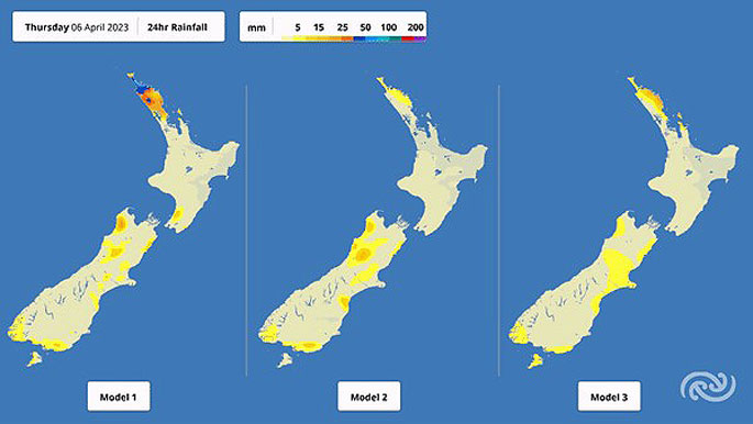
A large subtropical low pressure system is forecast to drift down from the north and bring wet weather to parts of the North Island from Thursday evening.
Although there is still some uncertainty on the path the low will follow, the MetService says there is a possibility that areas recently impacted by heavy rainfall will be affected.
Things kick off in Northland from Thursday, extending to the Coromandel Peninsula, Tairāwhiti/Gisborne and the Hawke's Bay during Friday, with the bulk of the latter two regions' rainfall occurring on Saturday.
How close to the country the subtropical low passes will determine which areas receive the highest rainfall.
The path of the low will largely depend on the strength of the blocking effect from a ridge of high pressure lying across the South Island from Thursday.
The first of that rain is expected over Northland from Thursday evening.
Areas from Russell northwards are under a Watch starting from 6pm, which could be extended to cover a larger area depending on where the low is located.
'This rain will likely be exacerbated by thunderstorms. These can bring pockets of really heavy rain to localised areas in a short space of time, which may cause surface flooding. It could be a bit hit-or-miss, but if it hits, the impacts could be significant,” says MetService meteorologist Mmathapelo Makgabutlane.
Friday afternoon brings a temporary break in the rain over Northland, though there will still be showers around before the subtropical low brings a new wave of wet weather later that night.
Things ease for a while late Saturday night and Sunday morning.
That wet weather extends to the Coromandel Peninsula late on Friday, with the majority of it passing through by Saturday night.
The eastern North Island sees that rain setting in from late Friday evening, starting in Tairāwhiti/Gisborne, spreading to the Hawke's Bay during the first part of Saturday, lingering until Sunday afternoon.
'MetService Watches and Warnings will likely be issued in the coming days, so it'll be a good idea for people to take this time to prepare. If things pan out in this way, it certainly won't be good news for vulnerable places still recovering from the recent severe rains,” Makgabutlane comments.
The passage of that low will also be felt as severe south to southeasterly winds over parts of the North Island, with stronger winds expected if the low passes closer to the country.
The most likely areas include the upper North Island from Waikato and western Bay of Plenty northwards Friday through to early Saturday, and then for Manawatū, Horowhenua and the Kapiti Coast on Saturday.
As the low continues southeastwards away from the country, Sunday brings brief respite.
Not for too long, however, with a front from the Tasman Sea sweeping over the country during the second half of the Easter weekend, delivering at least some wet weather for most across Aotearoa New Zealand.
While there is rain in the forecast, the good news is that across the weekend, most places will see some fine breaks and spells of better weather.
With holiday preparations for the long weekend already underway, people are advised to stay updated with the latest severe weather information on MetService.com as part of their planning.
 Image: MetService.


0 comments
Leave a Comment
You must be logged in to make a comment.