Analysis - The tornado or damaging wind that smashed through part of east Auckland about 9.30pm on Sunday was associated with a line of thunderstorm clouds moving quickly from the west to the east.
Such damaging winds could happen when thunderstorms were "particularly vigorous", says MetService meteorologist Dan Corrigan.
On Sunday night, the thunderstorm cells were lined up in such a way that they fed into each other and kept each other going.
The weather feature that caused the damage may well have been a small tornado, but MetService was uncertain because it had not seen any photos or video that showed a funnel cloud reaching to the ground.
"You can have strong down drafts out of thunderstorms that produce damaging wind gusts."
The risk of damaging winds was the same, regardless of whether they came from a small tornado or from gusts.
Between 8.30pm and 9.30pm Sunday, the strongest gusts recorded in the Auckland area were in exposed locations - 96km/h at the Tiritiri Matangi lighthouse and 87km/h at Whangaparāoa.
Wind speeds at East Tāmaki would have been much higher than that, Corrigan said, but he could not give a range.
There is uncertainty about the number of tornadoes in New Zealand each year and it is thought some in remote areas are probably undetected.
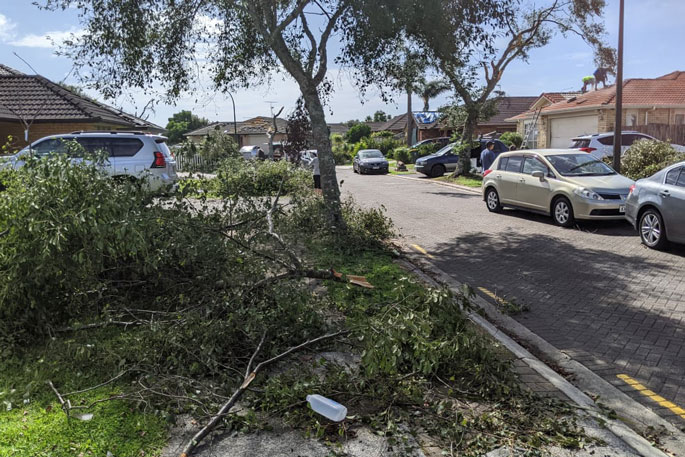
 Trees damaged in East Tāmaki. Photo: RNZ / Matthew Theunissen.
But so far in 2023, two events thought to have been tornadoes have been reported in this country - in Greymouth in March, and at Waihi Beach in February.
NIWA meteorologist Dr Richard Turner has said the typical number of tornadoes observed in New Zealand was roughly about seven to 10 a year.
Some years had more, maybe as many as 20 or 30, but some of those would not have been observed.
Based on observations and past studies, researchers thought areas of New Zealand most likely to have tornadoes were Taranaki, the West Coast, Horowhenua, and the Waikato coast.
It is hoped researchers will get a better idea of the number of tornadoes in this country from a project under way at NIWA, where three decades of weather data is being run through powerful computers.
Huge amounts of information is being produced, which will need significant analysis, but it is thought one output could be a better understanding of the tornado risk in different parts of the country, along with the changes in risk over time.
Researchers could also look for factors that influence changes from year-to-year, such as the impact of La Niña or El Niño.
NIWA described tornadoes as large rotating columns of air - a vortex - that happened in association with a thunderstorm.
Tornadoes had winds that travelled at very high speeds around a central area of very low atmospheric pressure.
The parent thunderstorms typically had very strong updrafts with speeds of 36km/h, and which were developed in an environment that caused the updraft to rotate, potentially causing a tornado, NIWA said.
Updraft speeds of more than 150km/h or more had been reported in the United States but not in this country.
In New Zealand, most tornadoes were associated with bands of thunderstorms embedded in a strong, unstable northwesterly flows ahead of a front.
"The thunderstorms have very strong updrafts and if these occur in an environment in which the wind directions rotate counterclockwise as the air rises, the updraft can start to spin," NIWA said.
In those cases something called a mesocyclone - a rotating vortex that can be as small as 1-2km in diameter - could form, and it is from mesocyclones that tornadoes were spawned.
Tornadoes in this country do not get to anywhere near the size of those that cause massive destruction in parts of the US.
Considerably less energy was available to storms in New Zealand, compared to the US, Turner said.
In the US tornadoes were linked to very warm, moist air near the surface, and very cold continental air higher up.
From 6pm yesterday to 6am this morning, 14,002 lightning strikes were recorded, 694 over land
— MetService (@MetService) April 9, 2023
The top 3 regions for lightning activity were Waikato (228 strikes), Nelson/Tasman (149 strikes), and Bay of Plenty (110 strikes)
⛈ More on the way today from the Tasman Sea pic.twitter.com/kXNfJPCZP5
Even in the US, most tornados were small, the US National Weather Service said.
But among the giants was the Great Tri-State tornado of March 1925 that killed 695 people in Missouri, Illinois and Indiana.
It travelled about 350km, causing three-and-a-half hours of "continuous devastation", had a damage path with an average width of 1.2km, possibly getting to 1.6km.
At one point, it was moving at a speed of 117km/h, and its wind speed was possibly greater than 480km/h.
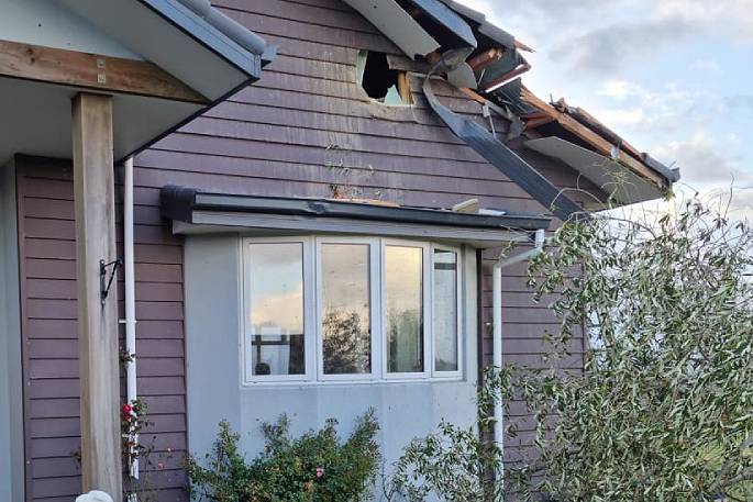
 A house damaged by another tornado that occurred in the Tasman district near Nelson at about 1.20pm on Monday, only 16 hours after the one in East Auckland. Photo: RNZ / Samantha Gee.
Tornadoes in New Zealand were usually about 20-100m wide, and travelled for just a couple of kilometres, Niwa said.
"They are extremely localised and the damage is very confined to the tornado itself, although the violent winds can fling debris hundreds of metres away from the tornado and cause considerable damage."
Most New Zealand tornados had wind speeds between 105 and 180km/h, rarely getting to 180 to 220km/h.
A tornado that killed three people in the Hamilton suburb of Frankton in August 1948, and had a path 100-200m wide, had wind speeds of 220-265km/h.


0 comments
Leave a Comment
You must be logged in to make a comment.