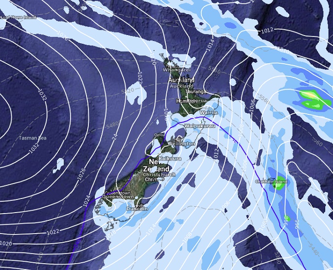
A cold change that pushed over the South Island on Sunday afternoon and evening is now moving over the North Island leaving a southwest airflow in its wake.
A cold blast is coming with more unsettled weather ahead says WeatherWatch.
North Island
Partly cloudy in the west, occasional showers. Showers clear Waikato northwards from late morning although one or two could remain in the west north of Auckland.
Showers Taranaki southwards in the west thin out this afternoon, clearing by evening.
Bay of Plenty has a mix of sun and cloud, mainly dry. Showers push up the east coast this morning with gusty southwesterlies (strong to gale about the coast), showers thin out this evening then becoming restricted to the coastal fringe overnight. Snow flurries for the Central Plateau are possible above 900m.
South Island
Southwesterlies for all today, strong to gale about coastal parts but starting to ease from afternoon, dying out in the east this evening.
The West Coast is sunny however showers north of Greymouth clear away this afternoon, Fiordland has partly cloudy skies and showers, becoming restricted to southern Fiordland this afternoon. Nelson has a mix of sun and cloud, showers for Marlborough clear this afternoon but clinging on about the Sounds till evening.
South of Rakaia in the east through to about North Otago expect some sun to start then cloud increases late morning before breaking away in the evening.
North of the Rakaia river rain this morning clears from the south to sun then cloud moves back in this afternoon, breaking away this evening. Southland and the rest of Otago has showers, perhaps rain this morning, gradually easing and clearing this evening, snow above 600m.

MSLP / Rain map – Monday April 24 2023 12:00pm – GFS Weatherzone.com.au
MetSevice has issued a severe weather watch, with gales expected, for parts of southern and central New Zealand
"A front is expected to move northwards across southern and central New Zealand on Tuesday and Wednesday morning, preceded by westerly gales in some places," says a MetService spokesperson.
"This Watch is for the possibility of severe gales about the south coast of the South Island, the Canterbury High Country, western Tasman, and parts of Wairarapa and Central Hawke's Bay."
People are advised to keep up to date with the latest forecasts, in case further areas are added or upgraded.
Strong Wind Watch
Area: Wairarapa north of Pahiatua and Hawke's Bay south of Hastings
Valid: 11 hours from 10:00pm Tue 25 Apr to 9:00am Wed 26 Apr
Forecast: Westerly winds may approach severe gale in exposed places.
Area: Tasman west of Motueka
Valid: 8 hours from 11:00pm Tue 25 Apr to 7:00am Wed 26 Apr
Forecast: Westerly winds may approach severe gale in exposed places.
Area: Canterbury High Country
Valid: 9 hours from 4:00pm Tue 25 Apr to 1:00am Wed 26 Apr
Forecast: Northwest winds may approach severe gale in exposed places.
Area: Coastal parts of Southland, Clutha, also Stewart Island
Valid: 12 hours from 4:00am Tue 25 Apr to 4:00pm Tue 25 Apr
Forecast: Westerly winds may approach severe gale in exposed places.


0 comments
Leave a Comment
You must be logged in to make a comment.