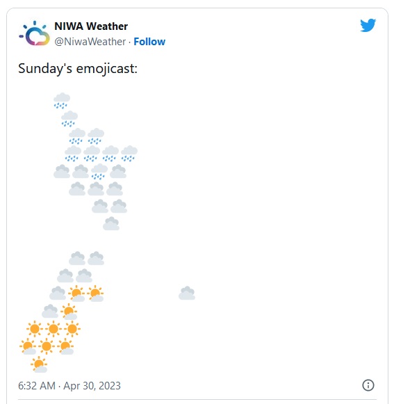
MetService says there have been some heavy rainfalls recorded overnight in Northland as a belt of wet and windy weather moves across the upper North Island.
It says 10mm of rain was recorded in Kaikohe between 2am and 3am, and again between 4am and 5am.
MetService has issued a Severe Weather Warning on Sunday morning with heavy rain and easterly gales expected for the upper North Island and northwest Tasman.
An active front associated with a subtropical low is moving south over the upper North Island during today and Monday, then onto central New Zealand on Tuesday, bringing periods of heavy rain and easterly gales.
Warnings and Watches for heavy rain and possible severe gales are in force for parts of the upper North Island and northwest Tasman.
Northland and Coromandel are both under orange heavy rain warnings, with MetService warning the expected downpours could cause rivers and streams to rise rapidly and make driving conditions hazardous.
SH1 AKL HBR BRIDGE - 6:10AM
— Waka Kotahi NZTA Auckland & Northland (@WakaKotahiAkNth) April 29, 2023
A strong winds warning is currently in place on #SH1 Harbour bridge. Please take extra care especially if you are in a lighter or high-sided vehicle or riding a motorcycle. ^EH pic.twitter.com/xsGt1IUOhI
A heavy rain watch is also in place for Auckland and strong wind watches are in force for Northland, north Auckland, Great Barrier Island and Coromandel.
There is also a strong winds warning in place for the Auckland Harbour Bridge and Waka Kotahi is urging motorists to take care.
Orange Heavy Rain Warning: Northland
— MetService (@MetService) April 29, 2023
There have been some heavy falls recorded overnight, with 10mm recorded in Kaikohe between 2-3am and 4-5am.
Watches & Warnings will be updated this morning; keep up to date here: https://t.co/qHyE5zzql5
Northland Rain Radar pic.twitter.com/9SCfadvNN5
Thames Coromandel District Council says people needed to heed the warnings that up to 200mm of rain could fall across the entire district, with gale force easterly winds reaching up to 100 kilometres an hour.
Civil Defence Controller Garry Towler says people should prepare and make plans in case there were slips, falling trees, flooding, road closures or power cuts - as the bad weather could last up to a week.

Vector says it had been monitoring the electricity network overnight, as heavy rain and high winds began sweeping into Auckland in the early hours.
The lines company says suburbs that had overhead powerlines were at most risk from the latest bout of bad weather.
Chief Operations Officer Peter Ryan says crews had been on standby overnight and Vector was monitoring the state of the network 24/7.
"We'll be dispatching crews into the field whenever we get significant loss of outage, safety being paramount - some of the work we do can really only safely be conducted during daylight hours."
A Heavy Rain Warning is in place for the following regions:
Area: Northland
Valid: 16 hours from 9:00am Sun 30 Apr to 1:00am Mon 1 May
Forecast: Expect a further 60 to 80 mm of rain to accumulate on top of what has already fallen. Peak rates of 15 to 25 mm/h this afternoon and early evening with thunderstorms possible.
Note: Further heavy showers are possible Monday morning.
Area: Coromandel Peninsula
Valid: 32 hours from 9:00am Sun 30 Apr to 5:00pm Mon 1 May
Forecast: Expect a further 120 to 180 mm of rain to accumulate about the ranges on top of what has already fallen, with 70 to 100 mm nearer the coast. Peak rates of 15 to 25 mm/h expected from Sunday evening.
Area: Bay of Plenty west of Kawerau, including Rotorua
Valid: 36 hours from 2:00pm Sun 30 Apr to 2:00am Tue 2 May
Forecast: Expect 150 to 220 mm of rain. Peak rates of 15 to 25 mm/h expected Monday.
Note: Further heavy rain is likely Tuesday night and Wednesday, but there remains uncertainty with the distribution and amounts of rain. However this Rain Warning is likely to be extended in future issues.
Area: Tasman northwest of Motueka
Valid: 24 hours from 3:00pm Mon 1 May to 3:00pm Tue 2 May
Forecast: Expect 100 to 140 mm of rain. Peak rates of 15 to 25 mm/h expected from Monday evening.
Heavy rain may cause streams and rivers to rise rapidly. Surface flooding and slips are also possible and driving conditions may be hazardous.
RNZ with additional update from MetService

.jpg)

0 comments
Leave a Comment
You must be logged in to make a comment.