After a colder and drier weekend, wetter weather returns to many parts of New Zealand with MetService expecting another rain producing weather system to reach the country later this week.
The calmer yet cool weather experienced in the weekend continues into Tuesday although a front approaches from the deep south where showers turn to rain over Fiordland.
The front slowly pushes into the central South Island on Wednesday, resulting in a rainy day for the West Coast, Southland, Otago and eventually Canterbury in the evening.
In contrast, it will be mostly dry and mild for the North Island, with just a few light showers in the west.
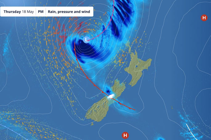
By Thursday, the front over the central South Island will have stalled and be weakening and still producing wet weather for the area but, attention will again be turning to the north.
'Yet another l low will be approaching from the north Tasman Sea with rain and strong wind ramping up over the upper North Island on Thursday afternoon and evening,” says MetService meteorologist Luis Fernandes.
The wet and windy weather quickly spreads across the North Island into Friday morning as the low edges closer, with a possibility of areas of heavy rain and gales for the upper North Island.
Heavy swells of up to 6 metres are also expected from the Taranaki coast, northward.
'This low is moving quicker than the previous weather systems that brought heavy rain and flooding earlier this year, most recently last week. However, with an already saturated ground, any further heavy rain could be problematic. An added complication is the wind is looking strong.”
This system will also bring rain to the upper South Island again and brings the next bout of rainy weather for Canterbury and Otago later Friday.
Luis says there is some uncertainty in the forecast for the end of the week.
'We used multiple weather forecasting models, and this far into the future they show many different options for how this weather plays out on Thursday and Friday. This makes it difficult for us to be certain about where and how much of an impact this system will have, so it's very important for people to check our website and mobile app for the latest forecasts as the certainty increases as we near the event.”
MetService meteorologists will issue Watches and Warnings associated with the events as models/forecaster become more certain.
They are keeping a close eye on developments especially for Bay of Plenty and areas in the top of the North Island.
The low is expected to over away on to the east on Saturday, with showery conditions still affecting


0 comments
Leave a Comment
You must be logged in to make a comment.