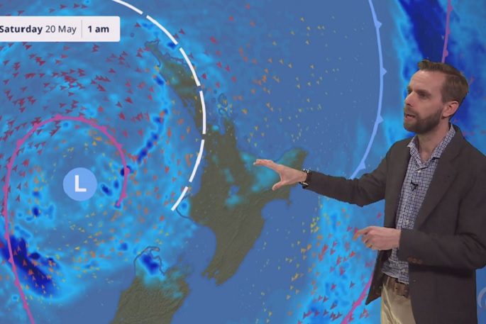
A deep subtropical low has brought stormy weather with heavy rain and severe gales to parts of the North Island, stretching into the top of the South Island, on Friday and Saturday.
The weather had begun overnight, with MetService expecting the heaviest rainfall on Friday to be in northern Gisborne, while in western Tasman it could last through Friday and into Saturday.
There's also a possibility of some heavy rain during Friday morning in Auckland, Coromandel Peninsula, and about Mt Taranaki. Heavy rain is possible through Friday morning to mid-afternoon in Bay of Plenty.
Northeast winds could approach severe gale strength in Auckland early Friday, through to late morning in Coromandel Peninsula, through to mid-afternoon in Bay of Plenty and eastern Waikato, and throughout the day in northern Gisborne.
Places most likely to have heavy rain on Saturday are eastern Bay of Plenty and the Gisborne ranges, Waitomo, north Taranaki across to Tongariro National Park, and northwest Tasman.
Places most likely to have severe west to south-west gales on Saturday are Northland, Auckland, northern Waikato, Coromandel Peninsula, and western Bay of Plenty.
The low that is the source of the stormy weather had already been responsible for heavy rain in the south and west of the South Island on Wednesday and Thursday, along with snow to 800m, says MetService meteorologist Peter Little.
A front tied to the low was bringing the heavy rain and gales to northern areas through to late Friday morning.
Unlike recent heavy rainfall events, that front wasn't expected to stall, and would move quickly southeastwards to be east of the country by midday Friday.
'However, surface flooding and slips are still possible even during this shorter rainfall event, as some areas may see heavy rain fall due to the tropical moisture and thunderstorms involved,” says Paul.
Very large waves affect the western North Island coastline from Friday
This is due to the combination of:
Deep low pressure
Strong onshore winds
High tides
Be sure to take extra care near the coast this weekendhttps://t.co/AlVlYMDz7z pic.twitter.com/BvfTnfKox5— MetService (@MetService) May 18, 2023
"A period of westerly gales will also affect northern parts of the country on Saturday as the low moves eastwards across the central North Island.
'The gusty westerly winds and already sodden soil, means people are advised to be prepared for power outages due to falling trees disrupting power lines."
Rain or showers were forecast for most places on Saturday, with the west of the North Island and Tasman region likely to be the wettest places.
Once the low moved to the east of the country a cooler, unsettled west to southwest flow would become established, says Paul.
Frequent showers were likely in the west of both islands through until at least early next week, with showers for eastern areas from time-to-time.
While Wellington may be missing the worst of the weather, it is still expected to have rain at times during Friday and Saturday, with southerlies strong by late Saturday.
The forecast for Christchurch has rain on Friday, with a few showers on Saturday and south-westerlies becoming fresh in the afternoon. Daytime highs are expected to reach just 12C on Friday and 13C on Saturday.


0 comments
Leave a Comment
You must be logged in to make a comment.