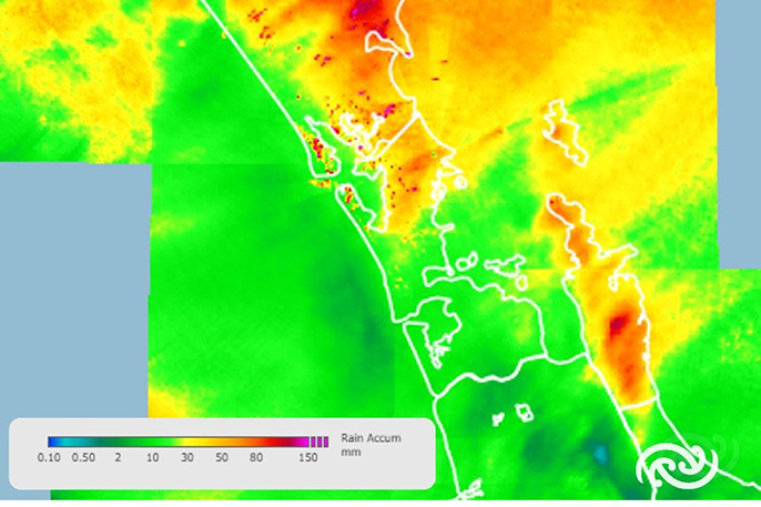
After a wet and windy Sunday and Monday in the upper North Island, MetService is forecasting a warm but active weather week ahead. Meanwhile, things in the South Island remain settled until an approaching low pressure system brings rainfall during the second half of the week.
Wet and windy weather looks set to continue on Monday and Tuesday for the North Island, after parts of Northland and the Coromandel Peninsula recorded 150 to 200 mm of rain in the 24 hours to 9am Monday.
Kaikohe had one of the higher accumulations in Northland with 150 mm recorded, nearly a month and a half’s worth of rain in 24 hours.
“The North Island is currently experiencing bands of rain brought on by a deep low pressure system that contains the remnants of Ex-Tropical Cyclone (TC) Lola,” says MetService meteorologist Mmathapelo Makgabutlane.
“As that low slowly continues eastwards, the zones of heaviest rain move along with it, impacting the Bay of Plenty, and later Tairāwhiti-Gisborne and the inland ranges of Hawke’s Bay. Parts of these areas are under Orange Heavy Rain Warning that go into Tuesday. Northland is not completely out the woods, however, and remains under a Heavy Rain Watch until Tuesday morning.”
Strong winds and large waves also featured overnight, with gusts in exposed areas of 120 to 140 kmh and waves of 4.9 metres measured in the Bay of Islands. “While generally windy conditions are still expected, the most damaging of those winds have now passed,” says Makgabutlane.
As Wednesday rolls on, the widespread rainfall from the low will have eased away, but the North Island and upper South Island, especially inland places, can still expect some showers, some of which could be thundery and heavy.
Into Thursday and Friday, the next low pressure system with its associated fronts sweep across the country, bringing rain as they move cross.
Warm temperatures are something to look forward to this week. Most regions reach upper-teens and into the 20s, with Tuesday and Wednesday looking to be the warmest of the lot.
The timing of these warm temperatures comes as MetService gets ready to commence its Heat Alerts for this season, starting on 1 November. These alerts will warn people in New Zealand of unusually hot weather. Look out for more information regarding this in the coming days.
Understanding MetService Severe Weather Warning System.
Severe Thunderstorm Warnings (Localised Red Warning) - take cover now:
• This warning is a red warning for a localised area.
• When extremely severe weather is occurring or will do within the hour.
• Severe thunderstorms have the ability to have significant impacts for an area indicated in the warning.
• In the event of a Severe Thunderstorm Red Warning: Act now!
Red Warnings are about taking immediate action:
• When extremely severe weather is imminent or is occurring
• Issued when an event is expected to be among the worst that we get – it will have significant impact and it is possible that a lot of people will be affected
• In the event of a Red Warning: Act now!
Orange Warnings are about taking action:
• When severe weather is imminent or is occurring
• Typically issued 1 - 3 days in advance of potential severe weather
• In the event of an Orange Warning: Take action.
Thunderstorm Watch means thunderstorms are possible, be alert and consider action.
• Show the area that thunderstorms are most likely to occur during the validity period.
• Although thunderstorms are often localised, the whole area is on watch as it is difficult to know exactly where the severe thunderstorm will occur within the mapped area.
• During a thunderstorm Watch: Stay alert and take action if necessary.
Watches are about being alert:
• When severe weather is possible, but not sufficiently imminent or certain for a warning to be issued
• Typically issued 1 - 3 days in advance of potential severe weather.
• During a Watch: Stay alert


0 comments
Leave a Comment
You must be logged in to make a comment.