The year 2023 was one dominated by extreme weather and where impactful events were unfortunately never far from our minds or our skies.
During the year, MetService issued over 300 Severe Weather Warnings across 61 events – a typical number for any given year.
"Not typical was that for five of these events Red Severe Weather Warnings were issued - with four of them happening in the first half of the year, which played a large part in a few of our weather stations breaking their wettest year record," says a MetService spokesperson.
The year kicked off with a number of tropical deluges, the most notable of which was Cyclone Hale.
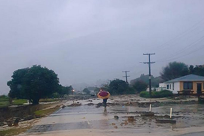
A State of Emergency was declared for Tairāwhiti/Gisborne from January 10 to 20 in response to the impacts it resulted in. Gisborne Airport recorded 252 mm of rainfall, the wettest January since records began there in 1937.
 A street in Gisborne following a storm in 2023. Photo: File.
The last week of January had a sting in the tail, with one of Auckland’s most extreme weather events on record.
A State of Emergency was declared over the Auckland Anniversary Weekend, following widespread flooding across the region.
Auckland Airport recorded 419.6 mm of rain over the event, six times its average January rainfall, making January 2023 the wettest month for the station since records began in 1962. One 24-hour period of the event saw 245 mm of rainfall, the wettest day on record for the station. Northland and Waikato were also placed under States of Emergency during this event, due to heavy rain around the end of the month.
The Coromandel Peninsula also saw significant impacts, where Whitianga Airport recorded 522.6 mm of rain – its wettest January on record as well. February Cyclone Gabrielle - February 12 to 15 - was one of New Zealand’s worst storms in recent memory.
Following a record-breaking wet January, impacts were catastrophic, widespread, and devastating across the northern and eastern North Island.
Tragically, 11 people lost their lives and countless homes and livelihoods where destroyed. A nationwide State of Emergency was declared on February 14, as Cyclone Gabrielle lashed the North Island – only the third time such a declaration has been made in New Zealand’s history and the first for a weather event.
.jpg) Karekare. Cyclone Gabrielle. Photo: David White/Stuff.
Karekare. Cyclone Gabrielle. Photo: David White/Stuff.
Aside from Gabrielle, downpours affected the upper North Island on multiple occasions in February.
A particularly active thunderstorm day on February 24 saw 79 mm fall in one hour, producing further flooding in north Auckland. Another thunderstorm also brought a tornado to Waihi early on February 25. In contrast, the lower South Island experienced an extremely hot, sunny, and dry February, until a rain maker brought some drought relief from February 21 to 22, followed by an unseasonable cold change that brought summertime snow to the southern ski fields. March The final week of March saw an unseasonably early cold snap, which brought sub-zero temperatures to much of the South Island.
This was accompanied by early snowfalls, where parts of Otago and the Canterbury High Country saw measurable snow accumulation, reminding New Zealanders that a change in season is just around the corner. April Subtropical lows dominated weather maps during April and brought further northeasterly rain to the upper North Island.
In addition, the general prevailing synoptic weather pattern resulted in recurrent heavy rainfall events for western regions of the country. A northeasterly flow also brought unusually mild conditions, with temperatures regularly exceeded the April average, including notably mild overnight temperatures. May This was another wet month in Auckland, which saw its wettest May on record with 271 mm of rain.
Kerikeri saw 378 mm, the wettest May there since records started in 1978. Kaikohe received a remarkable 585 mm of rain, four times its May normal, its wettest May since observations began in 1956. A significant part of these totals occurred during the first two weeks. Particularly, on May 9, thunderstorms lashed the upper North Island, delivering torrential falls of 40-50 mm/h from Northland to Waikato and Bay of Plenty. A local State of Emergency was declared in Auckland. Frequent northerly rainfall events also brought 490 mm of rain to Hokitika, double their May average. June A Red Rain Warning was issued on June 22 for Tairāwhiti/Gisborne during a week-long rain event, culminating in over 400 mm of rain about the ranges.
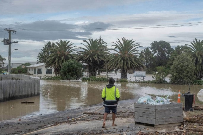
.jpg) Hawkes Bay flooding in early 2023. Photo: Hawkes Bay District Council.
Hawkes Bay flooding in early 2023. Photo: Hawkes Bay District Council.
Auckland remained wet through the month, officially eclipsing their average yearly rainfall of 1118.9 mm with 1135 mm of rainfall at the airport in the first 6 months of the year. In the South Island, parts of Otago experienced persistent freezing fog for days on end. July Northeasterly rain events from lows in the north Tasman Sea became less commonplace and were replaced by a more ‘normal’ west to southwest flow across the country.
Despite this change, a couple of lows from the north still occurred, bringing about slips from heavy rain in the Coromandel Peninsula, Tairāwhiti/Gisborne, and flooding in Canterbury. August Weather patterns during the final month of winter were characteristic of a developing El Niño.
Auckland experienced its coldest month in over a decade, while the North Island ski fields saw frequent top-ups of snow, leading to the best conditions in recent years. Not to be outdone, the South Island also saw below average temperatures, with Nelson recording its coldest month since 2004. September Severe gales returned to our shores, most notably on September 17 when Wellington saw damaging winds gusting 130-165 km/hr – the strongest gusts recorded there in over a decade. Extreme precipitation affected the south of the country September 21 to 22, with a State of Emergency declared in the Gore District and Queenstown due to significant flooding.
During this event, heavy snowfall also occurred in the high country of inland Canterbury, Central Otago, and the Queenstown Lakes. It was the fourth wettest September on record for both Queenstown and Invercargill, and the 2nd wettest September on record for Wanaka. A line of thunderstorms affected the Bay of Plenty and Tairāwhiti/Gisborne regions late in the month, bringing heavy rain. This led to the wettest September on record for Whakatāne. October October saw Southern Ocean fronts frequently move across the South Island. These fronts brought about numerous strong wind events, with damaging northwesterlies on election day warranting a Red Wind Warning in Canterbury. To end the month, an out-of-season Tropical Cyclone (Lola) formed, rapidly weakening as it approached our shores.
The remnants of this system brought heavy rainfall and severe easterly gales from Northland to Coromandel Peninsula, Tairāwhiti/Gisborne, and Hawke’s Bay. November It was another very wet month for the storm-battered regions of Tairāwhiti/Gisborne and Hawke’s Bay; Gisborne Airport saw its 3rd wettest November on record.
Wetter than normal conditions were also observed from the Bay of Plenty to the Wairarapa, and in exposed pockets around southern Canterbury. Conversely, the majority of the South Island had a drier than normal November. December Christchurch’s daily maximum temperatures tells a good story of the changeability that was present along the east coast of the South Island during December.
Christchurch Airport had a maximum temperature of 16.2°C on the 1st – up to 28.5°C on December 3 and back down to 12.2°C on the 4th with a few more similar temperature yo-yos before month’s end. A Severe Thunderstorm passed over Wellington on December 12 on an intense southerly change, bringing a burst of heavy rain, a smothering of hail, and even damaging winds (~140 km per hour) through Petone and Lower Hutt.
 A slip along State Highway 25 in Coromandel. Photo: Supplied.
Not surprisingly, the year closed with Auckland, Gisborne, and Napier breaking their station yearly rainfall records. MetService acknowledges the resilience of New Zealand communities in the face of these diverse challenges.
"As we turn the page to 2024, our commitment to providing accurate and timely weather forecasts remains steadfast. MetService operates 24/7, every day of the year, ensuring that New Zealanders stay informed and safe in the face of whatever weather may come."


0 comments
Leave a Comment
You must be logged in to make a comment.