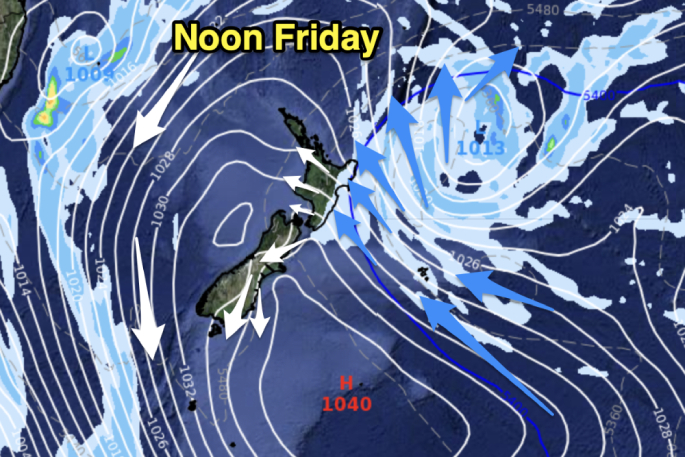
Temperatures will drop in a number of places over Friday and Saturday before milder weather comes in next week as high pressure continues to cross the country and drifts off to the south-east.
Showers move into the eastern North Island over the coming days as the colder air spreads across the country, with that airflow coming in from the east of the North Island and fanning our across the country.
7:30am Temperatures:
— WeatherWatch.co.nz (@WeatherWatchNZ) July 11, 2024
-8 #Omarama
-6 #Twizel
-6 #ArthursPass
-1 to -3 in #Hamilton
-1 Rural parts of #Auckland
Temperatures may still be dropping for another hour. pic.twitter.com/gLQ3kqierR
Where's all the #snow?
— WeatherWatch.co.nz (@WeatherWatchNZ) July 11, 2024
Next week it's falling in Australia's #Thredbo, and not so much New Zealand's #Queenstown. pic.twitter.com/afGXs5NJ8r
But the high is very powerful still, and it will continue to hold up low pressure and rain clouds out over the Tasman Sea - and it may not be until Monday that patchy rain develops in the very north of NZ.
 Weather Watch. Photo supplied.
A few showers are possible in Northland on Sunday as the Tasman Sea low looks to give the south-eastern corner of Australia a burst of severe winter weather.
IN LIMBO NEXT WEEK
Next week's weather looks messy as we're in limbo between the departing strong high and a fairly strong low on the Australian side of the Tasman Sea. Some areas will see rain clouds return, others - especially further south - remain drier (and that includes our southern ski fields).
Our Friday weather video (and again on Monday 15th) will have much more detail about how next week is shaping up as fractured rain bands move our way along with milder (for this time of year) northern airflows.
A high pressure zone for the record books! #NewZealand https://t.co/1yFDBhoHYD
— WeatherWatch.co.nz (@WeatherWatchNZ) July 11, 2024


0 comments
Leave a Comment
You must be logged in to make a comment.