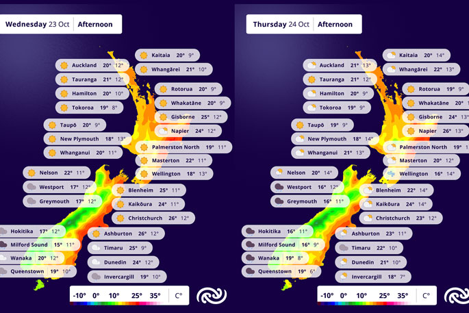
Largely settled and fine weather continues to be the main feature over northern and central New Zealand through to Tuesday evening.
But rain is being forecst for the South Island.
“As we head into Wednesday, warm and moist northwesterlies develop over the South Island, bringing rain to western and southern parts of the South Island. Fiordland has a Heavy Rain Watch in force from Wednesday to Thursday, which is likely to be upgraded to an Orange Heavy Rain Warning in the near future,” said MetService Meteorologist Dom Barry.
With this warmer air also comes warmer temperatures – many places across the east of the country will see higher than average maximum and minimum temperatures later this week.
“For the easternmost places like Christchurch, Oamaru, Napier and Hastings, maximums in the mid-twenties can be expected. Overnight temperatures will stay warm as well, in some cases only being a couple of degrees cooler than the day’s maximum, which might make sleeping a struggle for some.”
A series of fronts move up the South Island on Thursday, bringing rain to southern and western parts of the Island, as the high moves off to the northeast of the country, keeping things mainly fine and dry in the north.
While the fine, warm weather looks set to hold on for Hawke’s Bay’s anniversary day on Friday, the weather is looking more unsettled elsewhere as rain and wind returns.
“Low pressure is returning at the end of this week meaning some wetter weather is in store over the long weekend. With some drier weather possible for Labour Day, it is worth checking the forecast to get the best out of the weekend.”
 Image: MetService.


0 comments
Leave a Comment
You must be logged in to make a comment.