The worst of ex-tropical Cyclone Tam will lash the North Island today with heavier rain, stronger winds and “significant warnings”.
Fire and Emergency said it had more than 50 callouts overnight, 24 in Auckland and 33 in Northland, mostly relating to trees toppling in the severe wind gusts.
Motorists are being warned of potential road closures, and gale-force winds could halt rush-hour traffic this morning on the Auckland Harbour Bridge.
Thousands in Northland have been plunged into darkness this morning after a sweep of power outages overnight.
Residents from Whananaki on the east coast to Dargaville on the west and south to Tinopai have awoken to no power according to Northpower. It comes after 3500 homes lost power yesterday.
Fallen trees
In the Bay of Plenty, a tree has struck a car after strong winds caused it to fall onto SH5 north of Rotorua.
A police spokesperson said they were called at 6am.
“There are currently no reports of any injuries to the car's occupant/s.
“Contractors are en route to remove the tree, which has fallen between Waiohotu Rd and Galaxy Rd.”
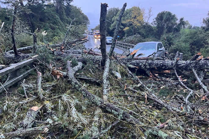
Meanwhile, a fallen tree has been reported as blocking SH29 between SH24 and Stopford Rd in Te Poi. Follow directions of response crews in the area and expect delays, said NZTA.
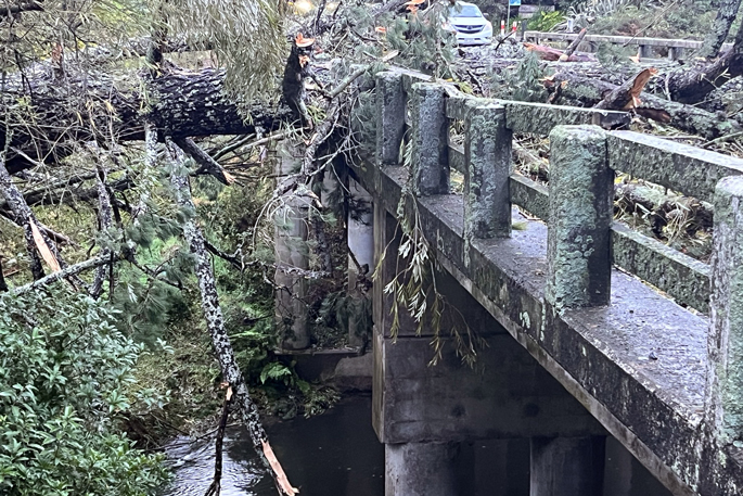
"A bridge on State Highway 29 east of Te Poi is blocked, after a tree fell acros the bridge this morning," said a police spokesperson.
"The tree struck a car when it fell - fortunately the driver was uninjured.
"Motorists travelling between Tauranga and Hamilton are asked to take alternative routes where possible, as the road is likely to closed for some time."
MetService meteorologist John Law told the Herald Northland and the east coast of Auckland are in for another battering today with the potential for 140km/h winds in exposed places.
“It’s been a while since we’ve seen such substantially strong winds, so people need to take extra care.”
Law said the “Coromandel in particular is in for a wet one”, and is at significant risk of surface flooding.
Maritime NZ said the winds forecast for the top half of the North Island today were set to be “the strongest since 2017”.
‘Very significant’ weather warnings
“Very significant” watches and warnings will be in place for much of today, Law said.
A number of regions will wake up to an orange heavy rain warning, including Northland and Coromandel Peninsula.
Later in the day, parts of Gisborne, Bay of Plenty west of Kawerau, including Rotorua and the Kaimāī Ranges will be under orange heavy rain warnings.
Easterly and northeasterly winds are forecast to reach unusually high speeds in Northland and Auckland, increasing the risk of damage to trees, structures and powerlines.
Cyclone Tam was officially reclassified yersterday afternoon as it moved south over cooler waters, changing the mechanisms driving the system.
While Tam is no longer a tropical cyclone, it remains a powerful and potentially damaging system with rainfall and strong winds expected over a wide area of the country in the days ahead.
MetService is continuing to use the term “Cyclone Tam” because of the potential impacts of the storm.
Forecasters don’t want people to get the impression the weather system is not serious or has already passed over the country.
Thunderstorms are possible today in Northland and northern Auckland.
Northeasterly gale winds are set to generate large waves on the Northland coast into this morning.
Swells of 5 to 6m are tipped to pound the coastline, with the biggest risk around high tide.
“Thursday’s looking quite messy, with really strong winds – gale-force through to midnight on Friday morning,” Auckland Emergency Management general manager Adam Maggs said in a video posted on social media.
Maggs urged motorists to take care, including checking the weather at their destinations “just to make sure you can be safe on the roads”.

0 comments
Leave a Comment
You must be logged in to make a comment.