An emergency alert has been sent out across the Bay of Plenty and Rotorua advising people to put their safety first as severe weather is forecast for the region. A red rain warning, the first for 2026, is in place for Coromandel, Bay of Plenty and Rotorua. In the 24 hours from 9am Wednesday to 9am Thursday, a further 180mm to 240mm of rain is expected on top of what has already accumulated. Peak rates of 25mm/hr to 40mm/hr could be expected in downpours from Wednesday evening, MetService warned. In this morning’s alert from the Bay of Plenty Civil Defence Emergency Management team, people are advised to act quickly if they see rising foodwater. “Do not try to walk, play, swim or drive in floodwater. “Avoid all non-essential travel. Bring pets indoors and move livestock to high ground where possible.” People are also advised to be prepared to evacuate. “Keep a bag close. If you are in immediate danger, call 111.” The current weather was being driven by a strong and extremely humid northeasterly flow that precedes a tropical low forecast to approach New Zealand from the north today, the MetService said. “The rain and wind should ease Thursday after the low crosses the country.” MetService said conditions would disrupt travel, make some roads impassable, and isolate communities. “We can expect 180mm to 240mm of rain, with peak rates of 25mm/hr to 35mm/hr. MetService has signalled there is a moderate chance of upgrading to a red warning,” a representative from the Bay of Plenty Civil Defence Emergency Management Group said. “We know this news might be worrisome, especially to those districts who have experienced significant rainfall in the last few weeks. “Streams and rivers may rise rapidly, and surface flooding is possible, so if you see rising water, do not wait for official warnings – head for higher ground and stay away from floodwater. Never try to walk, play, swim or drive in floodwater.” Bay of Plenty Civil Defence advised people not to travel unless it was an emergency, as there may be slips, fallen trees or surface flooding on roads. The organisation recommended drivers check with NZTA or their local council website for any road closures. In Rotorua, a Western Rd resident who didn’t want to be named said the Ngongotahā Stream was looking fine as of mid-morning Wednesday and should have a way to go before there was a risk of flooding. But she said locals would be keeping a close eye on it given the red warning and its past tendency to rise quickly. The resident said one of the issues in some areas of Ngongotahā with properties that backed on to the stream was wastewater grills and pipes blocking up and flooding so it would be wise for those locals to check those and clean them out if necessary. Lee-Ann Allerby, whose property borders the stream, said she was sitting tight at the moment and keeping a close eye on the stream. During previous weather events, the stream has burst its banks and come dangerously close to flooding the Allerby’s property. Meanwhile, SH2 through the Waioweka Gorge remained closed. Roading crews working to clear around 40 slips along the highway have paused work today. “With weather set to worsen over the day, crews will take a pause, rest, and allow the weather to pass before reassessing the site and resuming clearing work once safe to do so,” NZTA said in a statement. “SH35 remains open, however, it is not a reliable detour route while weather is severe.” SH2 south of Gisborne and SH5 remained open if people must travel. Additional crews were on standby to respond to any incidents on the detour routes. NZ Transport Agency Waka Kotahi SH2 Waioweka Gorge response and recovery controller Rob Service said keeping roading crews safe was paramount. ”This will allow crews to rest and return safely on Friday to continue recovery efforts over the long weekend.” Crews have been working from both ends of the SH2 Waioweka Gorge, as there has not been safe access through the central section since the slips last week. Damage was extensive, and the full condition of the road and underlying structures remained uncertain until debris could be safely cleared, NZTA said. “Our contractors are progressing well and continuing to push forward on what is a very large and complex task,” he said in a statement. “Our focus remains on restoring at least one lane of access. We do not yet know what this will look like or when it will be possible, but we will share updates as soon as we can.” Ōpōtiki side progress: Crews remained on track to remove 60 large truckloads of material from the Goldsmith slip - the first from the Ōpōtiki side and potentially largest (about 110m high and up to 60m wide). An additional truck has been brought in, with eight trucks and three diggers now active on this side. Two additional crews were focusing on drainage and opening culverts to reduce the risk of further issues. Gisborne side progress: Crews fully cleared two slips on Tuesday. Work continued on drainage and clearing blocked culverts. Teams were also supporting vehicle recovery where safe access allowed. NZTA was closely monitoring the upcoming weather system. The network was already in a fragile state, and there’s a risk that more loose material may come down. SH35 and SH2 south of Gisborne remained open, but long detours were required. There had been a significant increase in traffic on SH2 south of Gisborne and large numbers of vehicles through to Bayview. Travellers should delay travel where possible or allow significant extra time if using SH35 or SH5. Meanwhile, in the Coromandel, flooding was being reported on Wade Rd, south of Whitianga. Surface flooding was also reported around the region. SH25 from Whitianga to Tairua was closed, NZTA reported. “SH25 is also closed south of Whitianga near Wade Rd. This means Whitianga can not currently be accessed via SH25 from north or south,” NZTA said on Facebook. “SH25 is closed between Discovery Dr and Simpson’s Beach due to flooding. It is expected to remain closed for several hours.” Around 200mm to 250mm of rain was expected to fall in the Coromandel Peninsula until 6am on Thursday. Thames-Coromandel District Council advised people in a low-lying area to “please move to higher ground immediately”. “The Coromandel Peninsula is experiencing significant rainfall and more rain is expected today. Rivers and creeks are rising rapidly,” the council said. “We ask campground owners to proactively stay alert and manage any of their hazards.” New road closures: Kennedy Bay Rd near Mangatu Rd is closed. The Cooks Beach Community Response Group has been activated and was operating from the Cooks Beach Fire Station. The group was working alongside the Cooks Beach Campground to support the evacuation of about 35 to 40 campers, council said. “We ask campground owners to stay alert and proactively manage hazards at their sites. “Please take this warning seriously and act now to keep yourself and others safe.” Cooks Beach Resort manager Callum Murray said he had evacuated campers but still had caravans and campervans on site. “I’ve got a car almost completely underwater.” He said the campground was about 1.5m over the “normal” water level. “The bottom half of my camp is now a lake.“ Murray said the resort had about 100 people on site at this stage who were being evacuated to locals. “The civil defence unit is now set up, so they’ve got a sanctuary for people down at the fire station but at this stage, vehicles can move, so camper vans I’ve just got on high ground.” From 9am today until 3am tomorrow, MetService forecasts a further 200-250mm of rain on top of what has already fallen, particularly about higher ground. “Intense downpours this afternoon could reach 25-40mm per hour.” In a post on Facebook, the Thames-Coromandel District Council said the Fire and Emergency NZ fire alarm in Coromandel Town malfunctioned on Tuesday evening, causing it to sound continuously for about five minutes in a steady tone. “This was not a tsunami alert – there have been no tsunami alerts. “We’re aware of the concern and anxiety this may have caused Coromandel Town residents, and can assure everyone that there is no cause for alarm. “FENZ is investigating the issue and fixing it.”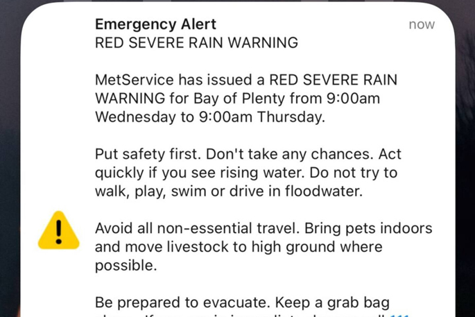 An emergency phone alert for a red servere rain warning has been sent out BY MetService in the Bay of Plenty.
 Ngongotahā Stream running high after heavy rain in Rotorua in 2018. Residents report the stream currently looking fine on Wednesday, January 21, 2026. Photo / Ben Fraser
SH2 Gorge slip update
 There are multiple slips along SH2, between Ōpōtiki and Gisborne. Image / NTZA
Evacuations
Fire alarm siren malfunction
Posted: 08:32am Wed 21 Jan, 2026
Emergency alert: Red rain warning for BOP
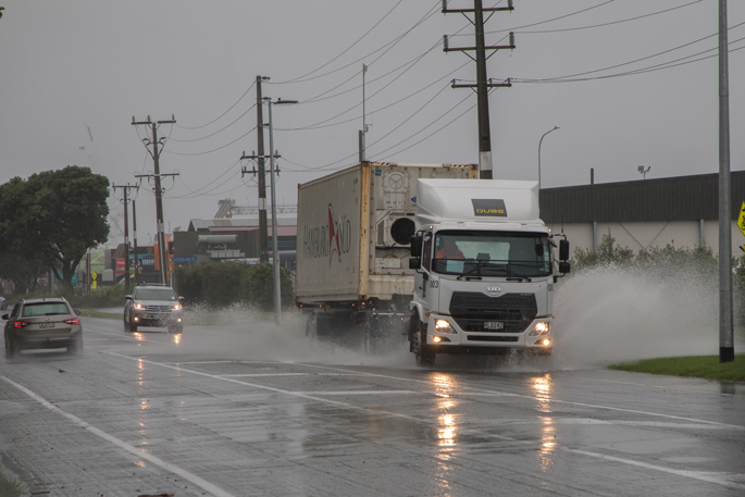
Rain has been steadily falling in the region and was expected to continue tomorrow morning. Photo / Jo Jones
21-Jan 13:24
Men flee after daylight theft at Tauranga store
21-Jan 11:45
Toi Ohomai:New chief executive signals fresh start
21-Jan 11:39
SH29 crash blocks both lanes in Lower Kaimai
21-Jan 09:20
Power pole left leaning after Tauranga crash
21-Jan 08:32
Emergency alert: Red rain warning for BOP
21-Jan 08:00
Tauranga Waitangi festival brings history to life
21-Jan 07:05
Soak’n Sounds turns 10 at Mount Hot Pools
20-Jan 18:00
Tauranga man sentenced to home detention
20-Jan 17:00
Surge in paddleboarders caught without lifejackets
20-Jan 16:10
Up to 240mm forecast in 20 hours for BoP
20-Jan 15:05
DoC tracks become half-marathon health challenge
20-Jan 13:02
Hat-trick claimed in Tauranga Half late run
COMPETITIONS

0 comments
Leave a Comment
You must be logged in to make a comment.