 |
Weather Eye with |
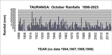
The graph below shows the range of Tauranga's October rainfalls, from an extreme high of 357 mm in 1916 to a low of only 7 mm in 1984.
The second wettest October was 1928, when 269 mm was recorded; and the second driest October was in 1928, when only 11 mm fell.
The long-term average rainfall for Tauranga in the month of October is 108 mm.
The rainfall in October 2023 was 84 mm.
The graph of the October rainfall shows generally normal variations from year to year but with a decrease from 130 mm in the 50 year average from 1911-60, to 88 mm in the 50 year average from 1961-2010, and this decease (to about 80 mm has continued in the average of the 12 October months from 2011-2023.

Since 1898, there have been 11 October months with a rainfall of 200 mm or more (10 of which occurred during the period 1900-1958), and only one October month since then has recorded this much. Eleven October months have also experienced rainfalls of 25 mm or less.
In chronological order the eleven wettest October months are 1900, 1905, 1916, 1918, 1921, 1926, 1928, 1941, 1952, 1958, and 1983. In contrast the eleventh driest October months are 1906, 1938, 1963, 1965, 1969, 1973, 1984, 1993, 2010, 2013, 2015 and 2020.
Tauranga October Average Afternoon Temperatures 1913-2023
Temperatures have been recorded in the Tauranga area at several sites in the last 100 years, including the current Tauranga Airport site from June 1990.
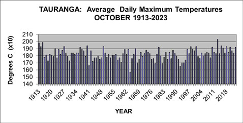
The graph shows details of the average daily maximum temperatures (called simply ‘afternoon') for Tauranga for October from 1913-2023.

The average afternoon temperature for October 2023 for Tauranga was 19.2 degrees C.
It's very common for areas such as Tauranga to have had different observation sites during the years, and readings from the earlier sites have been adjusted to the present site using standard climatologically procedures.The temperature series described here is a record of what the temperature would have been if the current observation site, Tauranga Airport, had been used throughout the period.
It's important to note, particularly in considering climate change, the methodology used in computing any “official” set of climate observations is very important as otherwise erroneous conclusions may be drawn.
Traditionally, temperature observations have been recorded with a set of maximum and minimum temperature thermometers.
These record the daily maximum temperature, usually recorded in mid-afternoon, and daily minimum temperature, usually recorded just before dawn.
The long-term average afternoon temperature in October for Tauranga is 18.1 degrees Celsius, ranging from the cool October months of 1964 (15.7 degrees Celsius), and 1992 (16.5 degrees Celsius), to the warm October months of 2013 (20.3 degrees Celsius), and 1915 (19.9 degrees Celsius).
The graph of the average afternoon temperatures for October shows generally normal variations from October to October during the last 100 years.The average October afternoon temperatures during the 50 years from 1962-2013 of 18.1 degrees Celsius was slightly cooler than the 18.2 degrees Celsius recorded in the 50 years from 1914-1961. However the last ten Octobers have shown an average of about 18.8 degrees C.
From 1913 to 2023, there have been seventeen October months with an average afternoon temperature of 19.0 degrees Celsius or more; and eight October months have had an average afternoon temperature of 17.0 degrees Celsius or less.
The five warmest October months (in terms of afternoon temperatures), on record, in chronological order, are 1913, 1915, 1940, 2013, and 2015.
By contrast, the fifth coolest October months (in terms of afternoon temperatures), on record, in chronological order, are 1941, 1964, 1978, 1982, and 1992.
************
For further Infomation about a wide range of weather/climate matters see my new book Climate Change A Realistic Perspective : The fall of the weather dice and the butterfly effect. Available from Amazon

