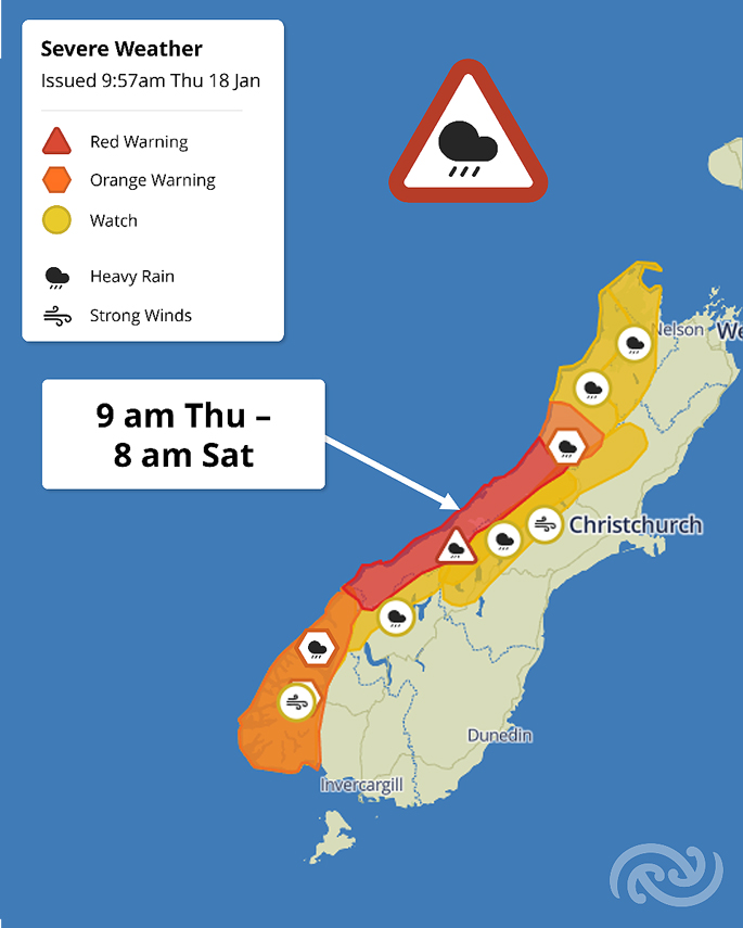
MetService has issued the first Red Warning of 2024 for impactful heavy rain in the Westland District of the South Island.
The warning is in effect from Thursday 9am to Saturday 8 am, with the heaviest rainfall expected from late Friday morning.
Heavy rain is also possible for the Coromandel Peninsula and Bay of Plenty, says the MetService in its latest upate.
Down south, the Westland ranges, encompassing popular tramping and camping spots, are anticipated to experience the highest accumulations, while the coast may witness lesser amounts.
Rainfall amounts range from 600 to 800 mm, with isolated areas potentially observing even higher amounts. This intense rainfall is predicted to result in rapidly rising river levels, leading to significant flooding.
The threat of landslides and floodwaters poses a risk to camping areas and road travel, potentially rendering some roads impassable and isolating communities and those enjoying the outdoors – trampers, and campers.
MetService meteorologist Mmathapelo Makgabutlane emphasizes the need for caution as this Red Warning bears similarities to the damaging flooding from March 2019 in which the Waiho bridge was washed away.
“Red Warnings are our highest warning level; they mean significant weather impacts are expected. People need to take immediate action to ensure they are safe, especially those camping near a waterway as there is a danger of flooding. For those planning a trip down south this weekend, be aware that this is a significant event and may affect travel plans. Stay up to date with the latest information on the MetService website and have alternative plans if needed."
MetService Red Warnings are reserved for the most disruptive weather events and are only issued after consultation with the local Regional Council and Civil Defence.
The remainder of the western South Island, from Tasman to Fiordland, is under either a Watch or Orange Warning for Heavy Rain between Thursday and Saturday. The Canterbury High Country may experience increased winds from Friday to Saturday, with a Watch issued for Severe Gales.
In addition to the Westland Red Warning, MetService highlights potential weather disruptions for the upper and eastern North Island from Sunday into Monday.
A low-pressure system drifting down from the north brings the possibility of heavy rain to areas that experienced a wet start to last year.
Notable regions include Northland, Auckland, Waikato, including the Coromandel Peninsula, the Bay of Plenty, and Tairāwhiti/Gisborne. This system may also be accompanied by severe gale winds.
”Stay informed and prepared for changing weather conditions.”
 Image: MetService.


0 comments
Leave a Comment
You must be logged in to make a comment.