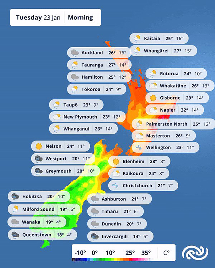
Tuesday and Wednesday is expected to bring a brief relief to most of New Zealand from the recent warm and muggy temperatures – only for things to heat up again heading into Thursday.
“An active cold front, followed by cool southwesterlies affects Aotearoa today and into tomorrow, bringing rain or showers to most, and sweeping out all that muggy, sticky air,” says MetService meteorologist Dom Barry.
“Temperatures tonight are set to plummet in many areas, with Alexandra forecast to drop to 3°C, and Queenstown and Wanaka to 4°C. Hastings will see a drop of 20°C, from 32°C to just 12°C tonight.”
The front is also expected to bring thunderstorms.
Today, there are risks of these forming from Northland though to Waitomo, as well as Taupo, Bay of Plenty, Hawke’s Bay, the Canterbury Plains and Marlborough.
The risk of thunderstorms reduces over the coming days as all the hot and humid air is swept away, and the welcome cooler temperatures dominate.
“The change to cooler air also brings the possibility of a light dusting of some unseasonable snow falling about the very highest parts of Fiordland, Southland, Southern Otago, and the Canterbury High Country. However, with the recent warm weather we have had heating the ground, it is unlikely any snow will settle.”
Wednesday sees a ridge of high pressure approaching the country, returning the skies to mainly fine, with showers in the eastern coasts.
Cloud remains for Gisborne.
The ridge of high pressure spreads over the country on Thursday, providing us with a period of settled weather for most, heading into the weekend, holding off the next rain system and confining it to Fiordland that evening.
With this, temperatures are once again set to rise into the mid-to late twenties for most.
This frontal system begins to erode the ridge and moves up towards Westland on Friday. It brings rain with possibly heavy falls to those regions, as well as a glimpse of what might be in store for the rest of the country in the weekend.
The Tropics remain active at this time of year and a potential tropical cyclone is currently brewing in the Coral Sea.
The current forecast is for this system to move westwards towards Australia and Queensland on Thursday.
While it is too early at this stage to know if this system – or a version of it – will impact New Zealand in early February, our team of meteorologists will continue to monitor the situation and keep you updated with all the latest information.
 Image: MetService.


0 comments
Leave a Comment
You must be logged in to make a comment.