An experienced storm chaser and adventure cameraman has captured drone footage of active volcano Whakaari/White Island’s crater during a phase of minor eruptions and heightened unrest this weekend.
Auckland-based Geoff Mackley, who was the star of Discovery Channel’s 2005 series Dangerman, wanted to be the first to record the recent activity at the marine volcano, 48km off Whakatāne, which has been closed to tourists since a 2019 eruption killed 22 people.
On Friday, GNS Science says there had been a minor eruption at the island, creating a “more vigorous” plume. It raised the volcano alert level to 3 and the aviation colour code to orange, both signifying a minor eruption.
On Sunday, GNS Science says a “continuous minor eruption” had started overnight and continued into the morning, creating a 1km to 2km high ash plume. The geological institution says short-lived steam and ash emissions could continue for some time, with a “low probability” ash would reach the mainland. Whakaari’s last minor eruptions were in late May.
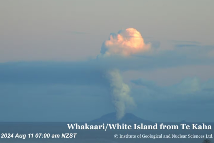 A plume captured on Whakaari / White Island by GeoNet cameras on Sunday morning.
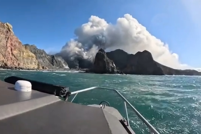
Geoff, who has been a cameraman for 25 years specialising in breaking natural disaster news, chartered a boat from Whakatāne with two volcanologists on Saturday.
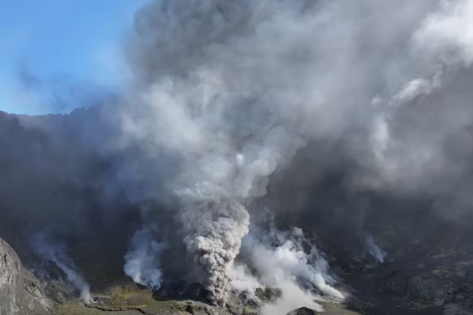
He says they used a drone with a “powerful” zoom lens to capture footage and collect ash samples.
”We flew the drone along the shoreline of the island into the edge of the ash cloud so that ash would land on the drone.
“They then swabbed the drone for ash samples,” says Geoff.
“We were a few hundred metres off because we didn’t want to be too close in case it blew up.”
Posting his video on his YouTube channel, where it has amassed more than 91,000 views, Geoff explained the sound in their recording was an overdub.
He told NZME the sound of the waves crashing on the beach made it “impossible” to gather natural sound. His team decided to match the crater sound to that from a trip to a similar-sized volcano, Dukono, in Indonesia.
“It’s identical audio from the same kind of volcano in another country,” says Geoff.
The footage shows vigorous activity in the crater, with grey steam billowing and includes a shot of a helicopter left on the island after being damaged in the 2019 eruption.
 Geoff Mackley, an experienced adventure cameraman and international volcano tour guide living in Auckland, used a drone to capture footage of White Island's crater. Photo / Youtube @geoffmackley.
Geoff says Whakaari felt like “a place filled with grief”.
“I also felt sad, as someone who’s taken volcano tours to places all over the world, that this needn’t have ever happened.
“Nothing in nature gives a s*** about what we’re doing.
“That high-powered steam coming out of the ground is unstoppable and, you know, water has the same power as high explosives.
“It would only take a bigger amount of lava to hit a bigger amount of a rock and you’ve got mud raining down on Whakatāne,” he says.
Possibility of major eruption ‘very low’
GNS Science duty volcanologist Geoff Kilgour says the possibility of a major eruption at Whakaari was “very low”.
“We have ways in which we can monitor the ground surface on the island to see if it’s bulging or subsiding.
“[Generally] in the lead up to larger eruptions, you get quite a large amount of ground moving, but in this case, we haven’t seen almost anything at all.”
He says ash from the recent events appeared to be being transported 1km to 2km downwind of the volcano but it was hard to tell due to cloud cover.
“Over the last 150 years or even more, our observations from the mainland is that it’s been very rare that volcanic ash has reached the mainland or impacted the mainland,” Geoff Kilgour told NZME.
He says GNS did accept samples from the public but this was not common or expected.
 GeoNet cameras record volcanic activity on Whakaari/ White Island on Sunday morning. Photo / GNS Science.
“Where people have collected samples then we’re more than keen to have a look at it and see what it tells us.
“We would need information like where was it located and where was it collected from - as long as it’s collected into one of those Ziploc lunch bags or something like that with a label on it.”
GNS would need to consider how it was collected in consultation with Maritime NZ, the Civil Aviation Authority and emergency management.
“We certainly don’t encourage anyone to take risks to their safety and advise people to refer to their local emergency management channels for local advice on keeping safe around geohazards,” says Geoff Kilgour.
GNS monitoring of the volcano via remote cameras and satellite imagery continues.
“Without an on-island monitoring network, changes in activity could occur at short notice. We will provide updates when information becomes available.”
‘Navigate with caution’
A Bay of Plenty Civil Defence spokesperson says people on the mainland would not be at risk from another sudden eruption but people on the water off Whakatāne should follow safe boating practices and use common sense.
“We support the latest advice from the Bay of Plenty Regional Council Harbourmaster to stay at least two nautical miles [3.7km] from Whakaari, or even better, ensure there is no safety risk by avoiding those waters altogether.
“Since Whakaari became more active several months ago, Bay of Plenty CDEM has been advising people to stay away from the waters around the island, regardless of whether the island has been at VAL (volcanic activity level) 2, or when GNS Science has raised it to level 3 after an eruption.
“The advice doesn’t change between levels because an eruption is possible at any time.”
The Bay of Plenty Regional Council posted a message from Harbourmaster Jon Jon Peters on Facebook on Friday advising boats to “avoid the area around Whakaari until further notice”.
“People put themselves and their vessels at risk of harm by being close to the island if there is a further eruption. There may also be debris and ashfall around Whakaari, so please navigate with caution.”
In response to the video, the council says on Monday that Jon Jon “reiterates that the advice to vessels to stay at least 2 nautical miles from Whakaari is in place to protect those on the water if an eruption occurs”.
“In this case, the proximity of the boat to the ash plume indicates how vulnerable those on the boat were to any sudden change in volcanic activity.”
Geoff Mackley says before they set out, “there was no [distance] stipulation made by the marine authorities of how close you go they just told us not to go too close”.
He says drones could be flown over the ocean under 120 metres and he did not fly over the island as he understood that would require permission from its owners.
The December 9, 2019 eruption killed 22 people, mainly tourists visiting from a Royal Caribbean cruise ship, as well as two Kiwi tour guides, Tipene Maangi and Hayden Marshall-Inman. Twenty-five others were badly injured in the disaster.
This year victims were awarded $10.21 million in reparations after the sentencing of the island’s owner Whakaari Management Ltd, White Island Tours and Volcanic Air Safaris. Charges were brought against them after a WorkSafe NZ investigation. The NZ Herald reported in March civil court cases have also been lodged in both Florida – where Royal Caribbean has its headquarters – and Australia, from where many of those killed and injured came.

1 comment
WOW
Posted on 13-08-2024 09:08 | By Yadick
What absolutely magnificent drone footage. Thank you to all involved in getting it. Was exciting to see.
Leave a Comment
You must be logged in to make a comment.